Photo-a-Day (Wednesday, 18th February, 2015)
Boundary stone
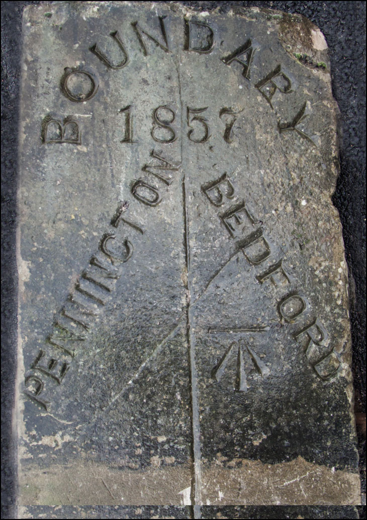
Photo: Roy Hesketh (Canon EOS 50D. 17-85mm lens.)
good picture bit of history ,does the arrow mark mean something to to do with ministry of defence,?
They built these Boundary stones to last.
Biggest one Ive seen when Im out on my travels is the one at Bryn, it must be 4 foot tall and the markings on it say, To Bryn station 640 yards and to Wigan 4 Miles
On the other side it says, to Ashton village 1090 yards and To Warrington 8 miles
JOE
Its a crows foot mark indicating the hieght above sea level.
Joe, it's a benchmark.they were used for levelling.
I think the arrow relates to "Ordnance Survey" used when mapping districts - miles etc, of course, I may be wrong !!!.
The arrow is a survey mark.
Joe, benchmarks or cut marks as these markings are known, are the lowest order of all Ordnance Survey instruments of measurement, primarily for the purpose of establishing levels in a given locality.
It's an ordnance survey bench mark.
Joe, I think the arrow mark is called a bench mark and it is used to identify government property or official government associations.
The arrow signifies Sea Level.
thanks for all your replies I am never to old to learn .
There was a row of Boundary Stones like these in the grounds of the former Astley Hospital now known as Dam House, they were on the Hough Lane side.
The arrow signifies...
THIS WAY UP
of course...
Interesting pic though, Roy...
I'm intrigued about Bedford - which Bedford would that be?
Bedford village in Leigh
This is from before Leigh as a single town actually existed.What we now call Leigh was then a collection of villages such as the two above and Atherleigh and Westleigh.
Could it be a datum line?
It's the datum reference mark that the bloke with the theodolite take his first reading from
I think David is on the bit side of Fred. Do t you think
The "arrow" as some yokels refer to it is actually ( A secondary benchmark cut by people like me who worked for the ORDNANCE SURVEY) The data from them give's one the correct hieght above sea-lavel based from the original tide gauge bench mark at NEWLYN in CORNWALL I hope this helps , as i say iv'e actually cut hundreds, one will find these under railway bridges/ church towers/ really any building that has a sound base , the next up are the gun metal ones set into solid brickwork those are an higher degree of measuring, and from these one can do many surveying items all from that fixed point .