Wigan Album
St Mary's Football Team, Ince
13 Comments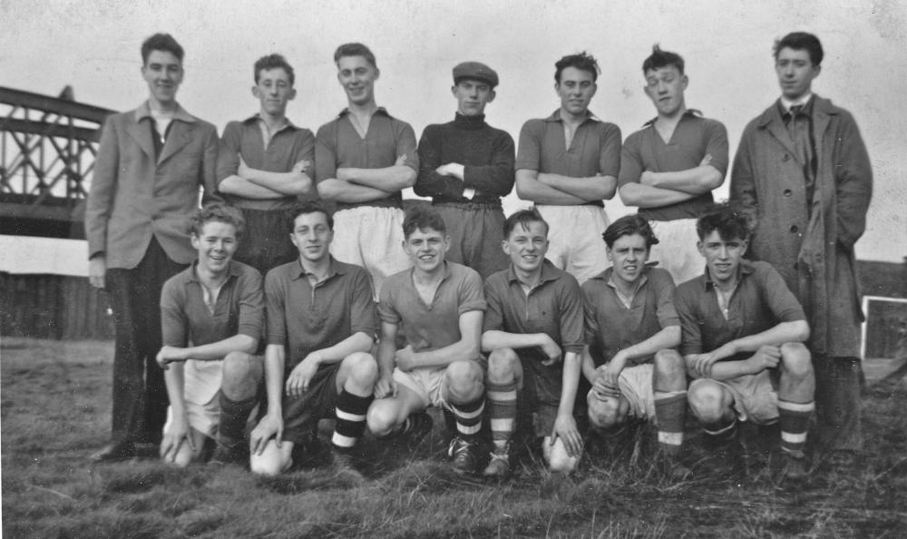
Photo: Rev David Long
Item #: 15501
Was the pitch down a dirt track opposite the church.If so I played against them for Garswood in the Wigan and district Sunday School League. Happy days.
The track is still there Frank, its called Donkey lane, and runs behind Vartys and crosses what was the line up to the wagon works and eventually top place in the early days, but I always thought that the trenchy was on the other side of the track, standing behind the Old St Marys church the one I mean is still in situ, belonging to the Wigan centre fishing club, ther was aflash on the other side but I didnt think that was called the trenchy, but I could be wrong
Thanks for that aitch.I remember they had a rope stretched across the water to get any ball back that went too far to reach.
In our old magazines the pitch is referred to as Trencherbone. It was, as I said, in the space between where the three lines met (the Irlam - Wigan line passing under embankment for the Pemberton Loop Line before going under the Springs Branch, which was on the level, and the spur off to the Wagon Works east of the line - the bridge for the crossing is still there. As for flashes around there - there was a big clayhole on the field immediately behind the old St Mary's, which was eventually infilled with rubbish. The new Holme Park Estate is built on the site. On the other side of the Ince Brook there were two smaller flashes, which were known as the Trenchies. They are still there, and are sometimes fished. On the other side of the Springs Branch there is a boggy area behind where the Hall of Ince was, confined by the Loop Line. Then there were ponds on the other side of the Loop Line, where the Clinic and an area of contaminated land is now. They were filled in with rubbish, too.
PS: The areas described above have largely returned to Nature - with vast bramble patches in many places. Yesterday I gathered 3lbs of blackberries from one patch (near Foster Avenue - where the path continues from Junction Terrace) - and left pounds more for others. We had the first, warm, jelly on hot toast for lunch... mmm....
derek latham mohican 2nd right back row pre beckham. where did it all go derek
Rev.David, a great picture, but which way is the camera looking? I can't quite square what you say about the location of the pitch and the two railway lines in the background. If it was in the triangle between all three lines it must have been an awfully small pitch? Is the line behind the sleeper fence the GCR branch to Wigan Central or The Springs Branch to Top Lock etc? The lie of the railway lines makes me wonder if this bridge in the background is actually going over the GCR branch with us looking broadly towards the North East, but I can't see the need for such a large span bridge there. The large span would indeed make more sense if it were passing over the throat of the lines wandering off to the left of The Springs Branch towards the wagon works which you mention, but then the orientation of the angle of the bridge looks wrong somehow?
The line on the embankment and bridge is the Pemberton Loop Line. A section of embankment is still there. The bridge did span the Springs Branch and the start of the spur off into the wagon works. As for alignment, the Loop Line ran more or less West-East, so we're looking more or less due North. Yes, I think the pitch probably was a bit shorter than regulation length - also not well endowed with grass, I believe.
Thanks for the pic David....I Used to play for Bethel YC in the 50s and remember playing Ince St Marys on that very "field". On one occasion it was thick with fog and we lost 5..0......only saw two of the goals go in!....didn't believe the Ref when he said it was "five"....Happy days!
Played again'st Ince St Mary's in the early 50s I played for Stubshaw Cross boys club, the 2 twins where a rough couple of tackler's,was always a hard game, what a place to play eh
played for St Mary's Boys Club 1961/62 .We had a good team only lost 2games in 2 seasons.Got photo of our team @Wigan Rovers ground in Final ,still got medals .Go on to WORK (Ince page 11 ) better photo of bridge.
SORRY,That should be ( PLACES page 11 not work) .
Team L-R Back row -M Jarvis G Catterall J Proctor J Eaves
T Robinson D Latham C Holmes F-Row D Smith R Benyon D Crank
J Mosley R Groves A Sherrington