Wigan Album
Platt Bridge
17 Comments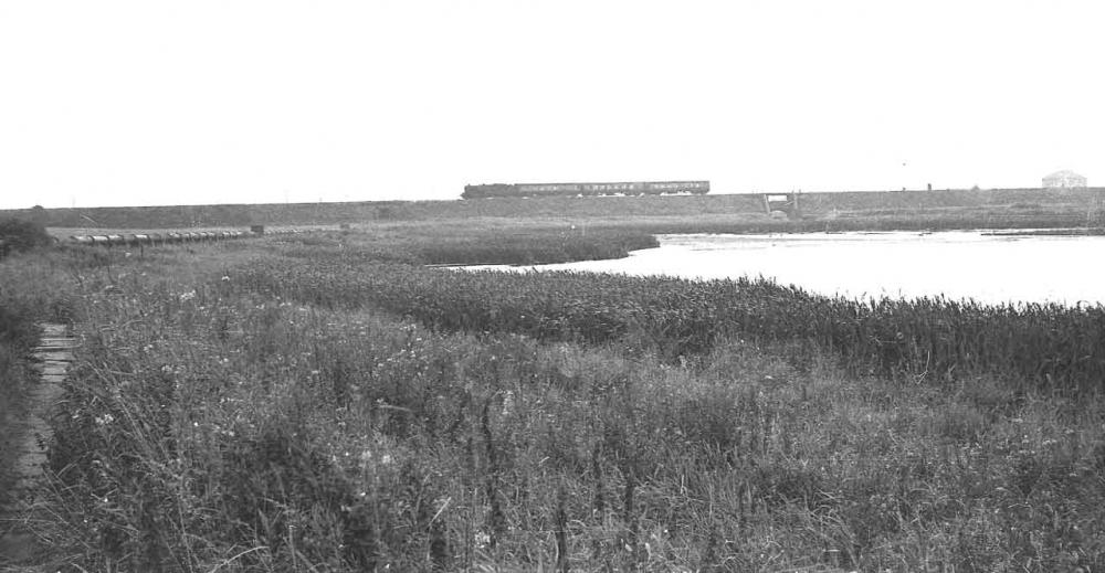
Photo: Thomas Sutch
Item #: 4989
Just as I remember it.---left Hindley in 1962.
Ta for the memory.
Great photo Thomas...just as I remember it! Used to play near that big pipe in the top left. Used to leave early morning and only come home when it was going dark...all ojust with a bottle of water and arrowroot biscuits! Thanks for your tremendous photos submitted to this Website...have you any of us 'Hunt's'...I think we lived next door to you in Bank Street, Platt Bridge!
Is that a building far left and if so does anyone know what it is? Thanks
The building on the left was part of Moss Hall colliery (Low Hall colliery ) in Platt Bridge.
brillian pic samys flood dried up now
yes we used to walk alongh the "black pipe" then go and paddle in sammy's stream but not until we had passed the "gypsy bridge" i used to be terrified they would come and get me!!!
Sammies Flood renamed Low Hall and is now a Local Nature Reserve. Hope you don't if I use your photo I am doing the history of the site, for the Friends of Low Hall, if you have any stories of playing round there i would love to hear then.
This was one of my main play areas!!! The Double bridge was built to carry the coal from wigan junction and maypole as well as low hall and connected with the LMS about a mile or so from where the train is. Three lines crossed at the meeting place, The great central (Wigan/Manchester) LMS (which is the one you can see) and the colliery line I have mentioned. For some reason it was calle TENBEDS locally, I never found out why. About 1944 a mate and I nicked a reserve petrol tank for a B26 Liberator bomber which were stowed at bamfurlong Cross tetley collieries we struggled to get it to spmewhere near where the photoo was taken. We hollowed it out and actually paddled it across Sammys, out of the brook which ran under the double bridge and down the brook to bickershaw lane where he lived opposite where the outfall for the cleanned sewage water is (or was.The building at the right rear was the Fan House for low hall collieries and it was not demolished at the same time as the other buildings since it incorporated the pump houe which kept all of the other collieries arround relatively water free. Best wishes
Me and my mates all Platt Bridgers used to play in this area in the early 1940s. We also built a raft using the aviation tanks for floats,Great Fun! Regarding the ten beds we used this term for another bridge going towards Platt Bridge station,the construction of the girders under the bridge formed ten beds which we would sit in. Not recommended whilst a train was passing over!
Famous locally for large pike!!
me and my friends use to love walkin and running across the black pipes,cant now thou, shame
The Friends of Low Hall LNR, have now brought out a history booklet about Low Hall LNR and can be picked up at Hindley Library,or by emailing me
the stream coming from sammy's flood was never called sammy's stream it was known as the cocky bruck. as the local name for the stickle back (small fish) was called a cocky that we used to catch there
we used to swim in the brook "early 1980s" beteen the path bridge and sammys pond, was clean then but just a polluted silt bed now.
we used to drop down into that void on the bridge over the brook. What was the idea for the void?
The pipe you can see was sewer pipe.We called it the pipe track.At the rear of where this photo was taken was a sewer pump house and it did smell awful at times We used to call this water big sammiies and the one closer to Liverpool road little little sammiies.When they where frozen over you could see pike under the ice.The pathway along the pipe track was made of old flagstones.Great picture brought back many happy memories.
Is that were we called over farm