Wigan Album
Scholes
3 Comments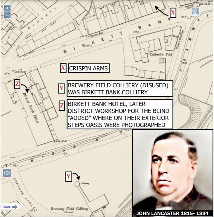
Photo: Keith
Item #: 35369
“X” the Crispin Arms (built around 1880). I lived here for 6 years in the 1950’s and the tiny square at the front of the building, to the right of the arrow, was the entrance to the small beer cellar. At the time of the map there were three pubs in Birkett Bank, The Raven Inn is shown on this map but by the 1950’s to my knowledge it wasn’t there.
“Y” Brewery Field Colliery was once known as Birkett Bank Colliery on earlier maps. As far as I can tell it was situated at the top part of Gordon Street. Once run/owned by John Lancaster (1815 - 1884) who was a key figure in the Kirkless Hall Coal Company and responsible for building 5 blast furnaces on the Kirkless site in 1860. Became Chairman of the Wigan Coal and Iron Company when Kirkless Hall Company was amalgamated with the Earl of of Crawford’s coal and engineering interests. He was an engineer, businessman, fellow of the Geological Society and Member of Parliament.
“Z” The Birkett Bank Hotel which later was added to with a District Workshop for the Blind.It was on their exterior “Blind Steps”, as they were known, that a front cover for a record by Oasis was taken some years ago in Darlington Road East.
There was another feature that with hindsight I could have included. Outside the Birkett Bank Hotel there was a very large gas lamplight, situated in the middle of the street at the junction with Scholefield Lane. Very faintly the initials LP (Lampost?) can just be made out on the map. It was here on the night of April 12th 1918, a large bomb exploded, dropped by the German Zeppelin intended for the Top Lock’s blast furnaces. A total of 17 bombs were dropped in Wigan that night (the original target had been Liverpool) and seven Wiganers killed. The lamp post was destroyed and, I believe, much to the annoyance of locals, was never replaced.
A very interesting map and information Keith.
A little further to the left on the map where Birkett Bank meets up with Hardybutts at the top of Edwin Street would be The Black Bull Pub to which both Aron Hunt and myself had family connections.
One minor correction if I may. It is Darlington Street East not Road.
Thank you Colin. Yes, I should have known better, I appreciate your correction. It’s at times like this that I realise I left my home town some 57 years ago. It also reminded me that I was corrected when I stated that nearby Clarington Grove (where my grandmother had lived) had been demolished, little realising that there is in fact a house there, still in existence.