Wigan Album
Where is this?
26 Comments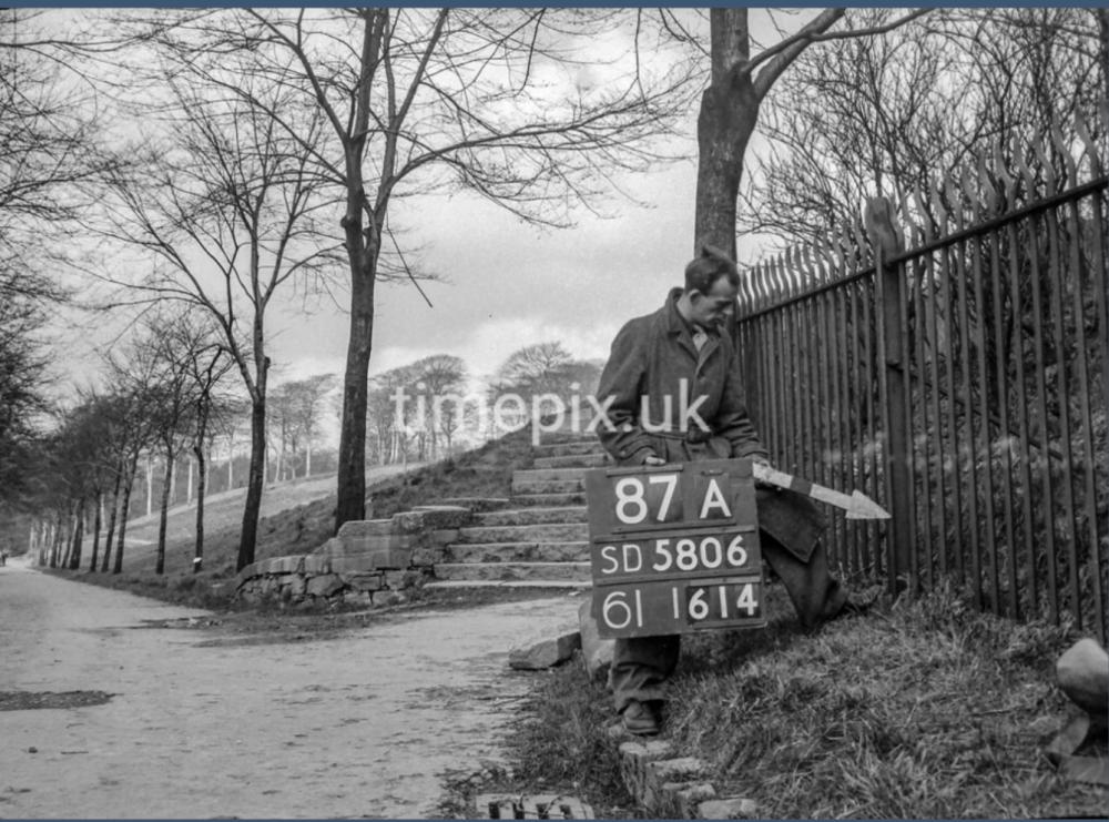
Photo: . Ozy .
Item #: 34990
Well , I ve had an enjoyable week uploading these images, but I’m surprised that Veronica and myself haven’t had our collars felt by the Timepix police before now , so I think I may make this my last one … but they’re all out there on the Timepix site for everyone to enjoy …
So go ahead … fill yer boots .
Great to hear that you have had an enjoyable week uploading the images, Ozy. I am quite sure that some of us have fully enjoyed this week's uploads from you.
Sorry to hear that this photograph of these steps leading up to the houses in Bottling Wood might be your last.
Thanks for uploading the images and giving us the opportunity to have a glimpse of earlier life in the Wigan area.
It’s so tidy and well cared for…I am guessing it’s near to the Hall itself.
Could this be the way to the Fish Pond. I know there was a slope upwards.
I’ll probably be hung, drawn and quartered but what the heck!
Veronica, it isn't near to Haigh Hall, but close to the bottom of Coppull Lane.
The steps are between the footbridge at the bottom of Coppull Lane/at the bottom of Maloney's Brew and the footbridge over the Yellow Brook, Haigh Plantations.
I think, the steps lead up to Walnut Avenue. Also, I think, the wide path which can be seen is Woodland Grove. Although, when I was young, my friends and I only knew it as the path that was at the bottom of Coppull Lane and went to the Yellow Brook.
Ozy, the Timepix photos are there for all to see on the Timepix Site, so I see no reason why they can't be shown on The Album....it's not as if there is a charge to see them. And, being from 1951, they are over 70 years old so there shouldn't be any "copyright" problems. Keep them coming, Ozy and Veronica!
Yes you’re right Ian I wish it was still the same. We always stayed on the right hand side on our way to the woods….we loved jumping over the yellow brook ..no bridge then! Just a few stones a bit of wood.
Only been there once in 60odd years I suppose it’s best not to go back and keep our memories.
Those steps are so familiar. The woods were our playground as children. Bottles of water and some jam butties and we were off for the day. Very often one of our gang would end up with wet feet, missing their step over the yellow brook, but what did wet feet matter when we had a day of freedom ahead.
Veronica, there was a type of bridge over the Yellow Brook when I was a very small kid, but it was just a couple of railway sleepers. Slightly later, these were replaced by a wooden bridge.
We (my friends and I) used the other path (the left side) at the bottom of Coppull Lane.
By the way, I typed Maloney's Brow. Unfortunately, mobile phones sometimes have a mind of their own.
Last year, when I went for a long walk to have a good look at the area, I didn't take that path to the Plantations because I wanted to have a look at the area around Coppull Lane/Maloney's Brow and area around Great Acre, then down to Scholes.
But, that area at the bottom of Coppull Lane has certainly changed and, I think, there is only one path from there (the footbridge) to the Yellow Brook.
Yes I remember Ian the ‘bit of wood’ were railway sleepers. What adventures we had then. I can remember crawling under a bridge inches from the water which seemed deep but that would have been further on.
I should have realised with the number 87a being practically the opposite of the other photo 87B. Daft me!
Not entirely sure of the location these steps but just love the picture.
I think the view today is probably very different either overgrown or built on.
Took this walk a month or two back and took a nice photo of the bridge over the Yellow Brook, unfortunately it did not get selected for pad.
I was born in Whelley and the surrounding areas were my playground but, until this series of photographs were posted, I never knew that the cobbled path from near the end of Moore St East and down to the bridge over the river and onto Coppull Lane was known as Maloney's Brow. I can 't believe it!!
Just wondering.
are those steps covered in undergrowth by now. I do vaguely remember them years ago. But we never went up that way.
My Dad always called it Larney's Bru.
DerekB, many of the areas weren't signposted or anything else to tell a person where they were.
As a kid and teenager, I do not ever recall a sign on Maloney's Brow, nor any sign at the bottom of Coppull Lane to tell you that you were in Coppull Lane (there was a sign at the top of Coppull Lane).
Also, there were no signs on the two paths which ran from the footbridge to the Plantations.
I believe, we knew these names: Maloney's Brow, The Scroggs, Devil's Cave, Devil's Canyon, King's Hill, Yellow Brook, Little Jungle, Camel's Hump, The Hermitage etc., because we heard the names as we were growing up and, naturally, we went and checked some of the places out.
As kids, we (my friends and I) also knew the name "Red Clogs".
How do I access the pictures on Timepix ? I have found the site and it’s search page, but cannot get into the photographs. What am I doing wrong?
Try typing in Timepix Wigan Douglas then you get the option of which area of Wigan you want to look at . It works for me anyway .
As a boy living in Chestnut Road, this was my way home from Wigan Lane, we used to call them “64 steps”
I've used these steps frequently, going between Balcarres Avenue and Wigan Lane. The area each side is heavily wooded and full of brambles - but the steps and ramp at the side are quite clear. They lead up to a 1950s estate above - to a road called Fellside - and then a snicket takes you onto Bradshaw Street.
The man in the picture is at the bottom of “64 steps” the top of the steps comes out at the junction of Rosemary Crescent and Walnut Avenue.The houses where built in the 1930’s by the council to accommodate the families of the old Bottling Wood whose houses down by the river were regularly flooded. I believe there is a plaque on the house at the end of Walnut Avenue and Chestnut Road which suggests these where the first of Wigan’s council houses.
Meg.Your father probably called it Larney's because the Barney family lived in the first house ,of about 5 non council houses inWalnut AvenueFor a couple of years I did Christmas post on Bottling Wood while still at schoolThe Larneys had fearsome dogs.I dreaded delivering there
I thought Larney's might be a coruption of Maloneys but it didn't quite fit so thank you Donald. I wonder if Dad knew the Larneys? Maybe he did.
Meg.The Barney Brothers were in business as property repairers
MegSorry I meant Barney,though one was Bertram
Rev. David, it is possible that you may be thinking about the steps where the footbridge over the River Douglas is. The steps shown above (photograph) are further along (further up the River Douglas and towards the footbridge over the Yellow Brook) and these were/are known as the "64 steps" that lead up to where Walnut Avenue joins Rosemary Crescent, as GrahamN stated.
The path/steps etc., which once was a cobbled path (before and after the above photograph was taken) was known as Maloney's Brow, leads up to Fellside. Most of the houses on Fellside, Greenacre, Rowanhill and West Mount - on this plot of land which was once known as Camel's Hump - hadn't been built when the above photograph was taken.
Ian - yes, you're right - I think both sets of steps come down at a similar angle - hence my confusion.
Meg,I did it again
I meant Larney