Wigan Album
Aspull
25 Comments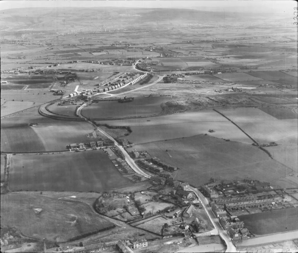
Photo: . Ozy .
Item #: 34929
Source : English Heritage. Aerofilms Collection. .
Don't think this is Aspull/Newsprings, nothing looks familiar what ever year it is.
Yes I can just make it out. Its not the Wutchie hill, its Rivington Pike.
Wutchie is to the very far right out of the photo.
Top lock canal and the pub Colliers Arms can been seen.
You have the username of Aspuller, and yet you cannot recognise the area on this aerial photo, I think you are a Boltoner and not long moved to Aspull.
Can make out the Colliers Arms pub,the 'Wutchie' is out of sight to the right I think.
WOW I cant believe how much property has been built since the photograph was taken. Any idea of the date?
The photo was taken on RAF flight UPSFFO8482 on April 23rd 1950 Ron .
This information comes from the English Heritage site .
The canal bridge at New Springs is clearly visible,
as is Higher lane .
Both Lords row and the Fingerpost area are clearly visible , and far from being to the far right and out of the picture ,
The makings of the Wutchie are smack bang in the middle of the frame . You can actually make out what I take to be a mineral line serving the Wutchie curving out and crossing Wigan road in the middle distance . Jeez .
I can assure you moss pitman that Aspuller is a true marrow.
Aspuller is correct with his assumption that the Wutchie is out of camera to the right.
Your right Ron, lots of space and green areas.
Why is Aspull’s population so low compared to the other villages ?
I just wondered if there was a historical reason of some kind . Thank you .
I realised the second that I hit the submit key that it’s Dukes row , not Lords row .
Well , we all make mistakes occasionally don’t we ? …. Well don’t we ?….
Maybe it’s just me then eh ?
Unfortunately, on this site , once you press submit , there’s no going back .
Ozy, I'd say you're 99.9% right most of the time.
You can make out the mineral railway line from the Alexander pit
To the left of the photo.
On second thoughts I'm not too sure if the mineral line is from Alexandre pit, there's also Lindsay pit too. There were many mineral lines around Newsprings and Aspull, also Kirkless to Springs Branch.
I can't get my bearings with this one. The canal yes but the Wutchie no.
Alexandra pit. Sorry got the spelling wrong.
Mark because it has only a small community. In other words not a big place.
Marrow? Jill it is glaringly obvious that you are not from around here or even Lancashire, put your wireless on Radio Lancashire and hear how folks say it, it is a corruption of moorer becoming marra, many folks from Lancashire and Cumbrian towns and villages call a friend or compatriot marra.
Mark then it was just that, a lone pit village, with the men from local pits living locally and doing as most did even myself, one getting out of a bed to start a shift, and another having done a shift getting into the same bed. The vast developments of council and private housing during the 1950s, 1960s and 1970s and even into the 1980s and 1990s, made a huge difference and there's little left of all that land you see, if you look around even now there is land here being sold for development. The views of Rivington I see from the house I live are thankfully still there, but you never can say for how long the view will still be there or the land will stay for farming.
It's defo newsprings and aspull.
Plenty open space. recognise everything.
thanks for sharing ozy.
Never heard of moss pitman on Pad before.
Everything visible is known to me, having been all over here for many years. I wish the roads were so quiet today.
Here's a part of the same photo - though magnified to show High Street and colourised, by AAH.
https://www.wiganworld.co.uk/album/photo.php?opt=5&id=31970&gallery=Aspull&offset=0
Ozy, though born and bred in Aspull I had to study the photo for awhile before I got to identify where it was. The key is to start at the bottom at New Srings Bridge, on left is the old Sawmill, right Bridgewater pub, on up Ivy Brow past the Delph, I can see Crawford Ave, I was born here 1947. No Hilton Estate yet or Moorside. What a fantastic photo, thanks for the memory.
Old Maps show that the area some are saying was the Wutchie in its early days cannot be that - it was taken in 1950 - all mining in this area had ceased long before - so no waste to form tips.
The area is actually the site of the Marsh House Coke Works - which were fed coal via that curved track to the left, from Crawford Pits - long gone, and with housing over its site and its marshalling yard up by the Fingerpost - and by Moor Pit No.5 off Scot Lane - again where housing can be seen on its site (it closed in 1923).
The War Memorial plaque for the No.5 pit is with others Wigan Coal & Iron plaques in the RBL club across the road from its site.
19 pits and works of the WC&I Co received similar plaques - but not, for some reason, Crawford Pits.
Regarding the Wuchie, this would have already been finished, it is just out of shot on right. If you follow the curved mineral line the bridge where it crossed Wigan Road close to the Delph has been removed, This is the line heading towards the Wuchie. When I was five years old my big sister would walk us along here. The first time I climbed Wuchie Rook was holding my sisters hand back in 1951 what a view over New Springs towards Wigan and beyond, 70+ years later I can remember it well.
Is that Aspull in the distance with New Springs in the foreground?
Think I can make out the bridge over the canal and the Colliers Arms on the left hand side set back at an angle.
I cannot make out the Finger Post nor dukes Row that are up there somewhere.
Colin - if you follow the road up from the Colliers' Arms, Duke's Row, with Moss Pits Houses to its right, are just past the bend after the track of mineral railway crosses the road, coming from the coke ovens - the disturbed land centre right. Fingerpost is to the left of the Methodist Chapel, pub etc, which are just lit of a line up from the Colliers' Arms. - about a third down the image.
I heard marra used, alongside butty, in Snowdown Colliery in Kent - which was worked by men from every coalfield area in Britain.
Sorry, still cannot make out Aspull properly, maybe it's because I am not used to seeing it look so rural!
I can see Higher Lane though branching off to the left that eventually takes you up to Haigh Hall.
Whoever was that RAF person that took the picture never thought that we would be discussing it 74 years later.
I’m trying to find the Running Horses then I’ll know where Bolton Rd/ Dicconson Lane is. Then on to the A.6 to Westhoughton I daresay it doesn’t go that far on here. But the Running Horses should be on this map. It looks like 2/3rds up towards the right there’s open land in front.
( the pub)