Wigan Album
Standishgate
15 Comments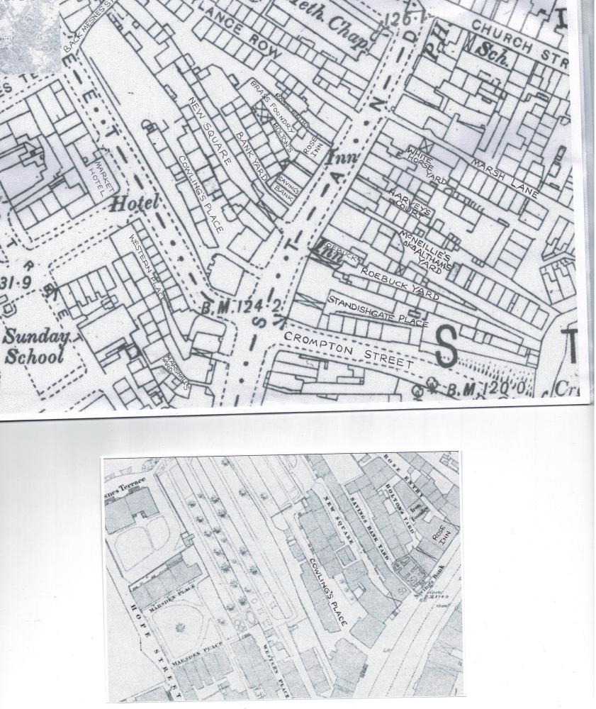
Photo: RON HUNT
Item #: 34847
THANKS TO JOHN FLEETWOOD.
Thanks again Ron and to John, these maps stir up so many memories, I need to study in detail before any further comment but just love them.
Colin, this shows the toilets on Marsh Lane were a covered alley to the White Horse Yard as I mentioned on your quite recent photograph.
Has anyone got any information on the ROSE INN? Must say I've never heard of it?
Rose and Thistle Inn. Rose Bridge Inn?
The ROSE INN as marked on this map..
RON; The Rose closed in 1903 [wigan pubs] Dog i,thatch 1970s,Roebuck1942
There appears to be much on these maps that raises many questions which may never be answered.
I don't know anything about The Rose Inn nor the Pub which is shown on the corner of Standishgate and Church Street, also the Savings Bank with Banks Yard at the rear.
The other yard, Cowling's Place ran at the back of the yet to be built extensive parade of shops on Mesnes Street known as Market Buildings opposite The Market Hotel. My assumption is that that block of buildings on the corner of Mesnes Street and Standishgate (today with Subway below) again yet to be built is named Cowling Buildings, I assume named after Cowling's Place that it was built on but who was Cowling?
I do remember the many old houses in and around New Square, they must have been demolished in the late 50's or early 60's and were a bit grim.
Also interesting to note that what is now The Royal Arcade was pretty much open to the elements and was known as Western Place.
On the smaller map Western Place appears to lead out to a small open space or park between Hope Street and Mesnes Street with streets either side known as Marsden Place, one now Marsden Street, could the Park Hotel built on this site have been named after this small park?
All quite fascinating, I wish I had more answers, I am sure there is much more to investigate and discuss.
The pub on the corner of Church Street was The Dog Ith Thatch and St. Georges School next door.
Hello. I have ancestors who lived in Queens Head Yard. Can anyone pinpoint where that was please?
It’s on the Big Lamp map, in the bottom right hand corner.
Just had a look at a Directory for 1888 and there is a ROSE and CROWN pub listed as being in Standishgate maybe it later changed its name to THE ROSE INN ?? More investigation required...
Found this in the 1869 Directory
Hart Robert, Rose Inn, 48 Standishgate
Now I need a photograph of the pub...
Ron, Grandad Jim's Traditional Sweet Shoppe, two doors down from the Ukulele (White Horse) is listed as 53a Standishgate so I am thinking 48 must have been on the opposite side?
Graham Parkinson - There was another Queens Head Yard which along with The Cross Key's Yard was demolished to make way for Library Street when it was constructed to join Market Place through to Rodney Street. The nearest remnant from that time is Barrack Square or Yard.
Maps are available that show this.
Colin, this is shown on the Big Lamp map which is prior to the construction of Library Street. Both the Cross Keys Yard and the Queens Head Yard are shown.