Wigan Album
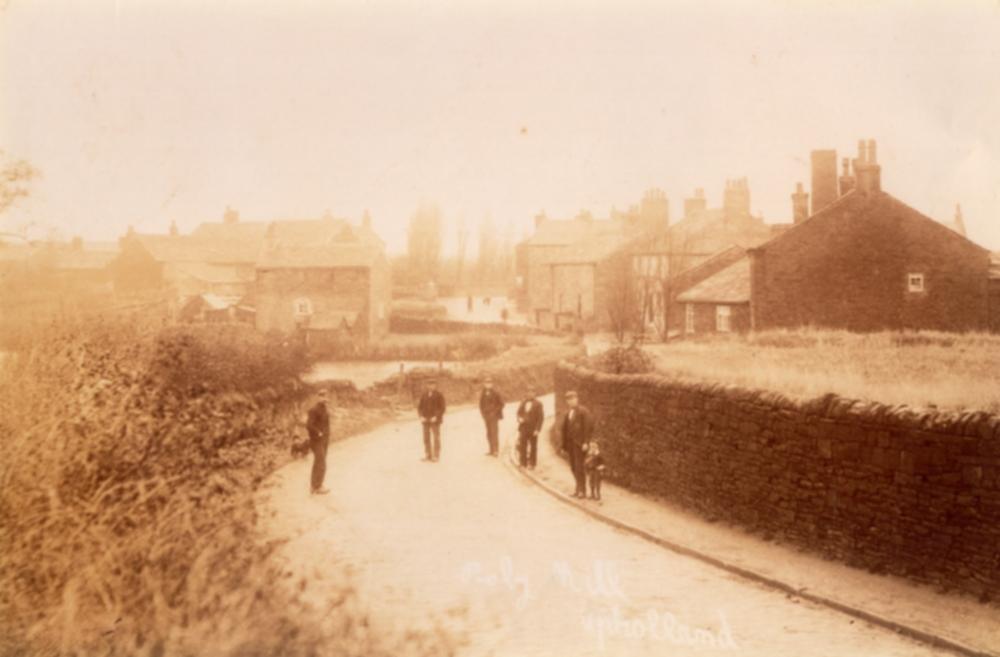
Roby Mill
13 Comments
Photo: Ron Hunt
Item #: 34508
What a neat photograph! Thanks for sharing ...
Good photo Ron. I think the gable on the right is, The Old Granary, now hidden in trees and the first gable end you see now, Millstone House, is further on past the lower building.
When we lived in Upholland we walked down to The Fox and The Star quite often, its a lovely area.
Hi Ron where did you source this photo from ? Do you have any more of Roby Mill ?
PHILIP. NO IDEA WHERE IT CAME FROM? IT'S BEEN LYING ON MY COMPUTER FOR A FEW YEARS?? JUST COME ACROSS A FILE WITH A LOT OF UPHOLLAND IMAGES... I'LL HAVE A LOOK IF THERE ARE ANY MORE OF ROBY MIILL
Thanks Ron; looking at historical OS maps the presence of the Roby Mill dam dates this possibly in the 1890s......it had disappeared and the road straightened something akin to what it is today by the 1920s.
Philip, Thanks for the info. What was the Roby Mil Dam? I can't remember there being a stream or river being there?? But I can't say I'm a regular visitor ti the area..
After extensive research with older relatives ...... it seems the dam was connected to the mill across the road to the right. From the OS maps It would seem to follow that it was designed to capture the water from runoff from the Beacon and the surrounding areas would stem flooding and also power the mill.. Even today flash storms cause flooding at this low point in Roby Mill though the dam is now situated behind the phone box.
Thanks Philip for the info. Is the dam open or is it covered over?
The dam was still evident in the 1970s especially when it was wet weather a with flash floods/storms. It gradually dried up and is overgrown now with trees which are behind Stone Cottage the house above the dam. As the dam dried up the wall was taken in and the road straightened by the 1920's-30's. Today the existing wall and pavement now run parallel with the outside of Stone Cottage.
Thanks Phil for the info. Do you know anything about the MILL I presume it was a water mill? Where was it.
The mill is directly across the road along with the Old Granary which the current owner has acknowleged with a name plate on the house. Today a bungalow sits on the mill site developed in the early 1970's. According to Dr. Allan Miller's Upholland in old picture postcards Vol 2 p40.....
"Other property was knocked down in the name of progress. In 1903 the old corn mill in Roby Mill was found to be in a dangerous state when it was planned to widen and raise the road at that point". The Millstone public house is on the right directly opposite the entrance to Farley Lane but looks to have ceased functioning as a pub (late C19) in this photo. I do know that when refurbished the builders found the cellar untouched with the barrel cradles intact frozen in time.
Having checked again the second building on the right does have a stone inlay with "Roby's Old Mill" engraved on it with the "Old Granary" in the foreground on the right. It may be part of the original footprint while another part was demolished for the purpose of road widening.
ARE THERE ANY PHOTOGRAPHS OF THE MILL? WHEN WAS IT DEMOLISHED