Wigan Album
Martland Mill
17 Comments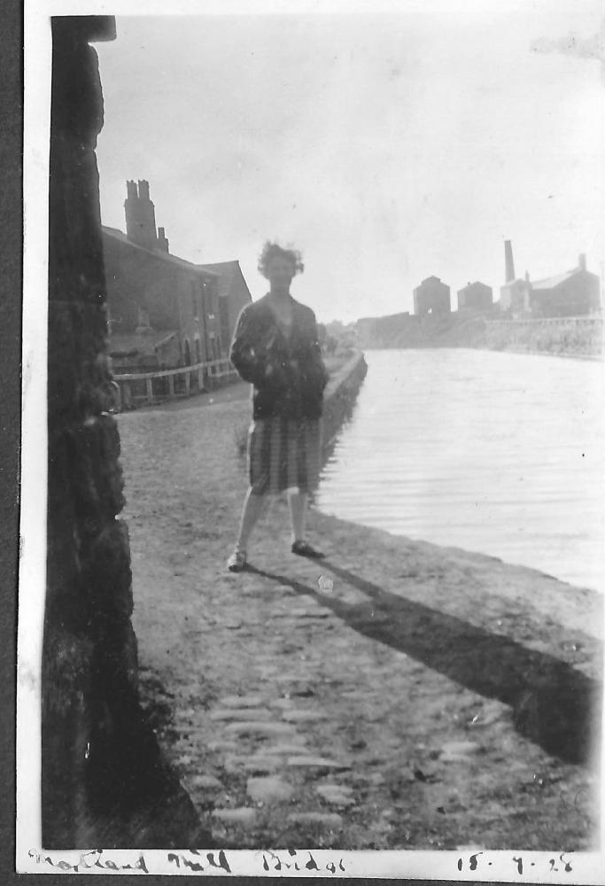
Photo: Barrie
Item #: 34429
Can anyone identify the building in the background on the opposite bank?
Your Mum as a lass Barrie, lovely.
Lovely memories that photo for you Barrie. Photos like this one are a treasure.
Barrie, the mill in the background would be the what they called the bone works, (this one being at Standish Lower Ground and not the one at Appley Bridge)
'Lloyd Abraham (established 1846), manufacturing chemist, Bone & Chemical Manure Works, Standish Lower Ground. - Edward Donohue, manager.'
From here: https://www.wiganworld.co.uk/stuff/townd1881stand.php
Interesting to see the buildings on the left which looks to be a farm, I never knew that these buildings had been there, thanks for sharing the photo Barrie
Stringfellow Removals was there later before houses being built on the land.
Immediate on the left will be the railway bridge abutment ,curve of the towpath just to get round the bridge. The buildings were the lock keepers house and his maintenance area.
Lovely memory to have Barrie. Although your Mother's face is in the shadow, you can see she is smiling broadly. Must have been a very happy day for them.
That is one very special photo! How happy those young people must have been that day, and how amazed they would be to know that we have been able to share in their happiness on Wigan World all these years on.
Great photo, Barrie.
I like all your old photos. Keep posting them.
Is this bridge still in existance?
A day to remember - walking along the canal in celebration and if they could have seen into the future with a photograph on Wigan World! …it’s as if it was yesterday. These records and diaries must really keep them with you in heart and mind Barrie, I envy you. As I have remarked before..
There is this map on the Wigan Archaeological site pages, you can see the buildings on the left behind Barrie's mother, unfortunately it doesn't say what they are. https://www.wiganarchsoc.co.uk/content/News_Letters/news239.htm
orrellite, are you thinking of the same bridge as this wasn't a railway bridge it was a wooden planked road bridge, which is still there. I've never know buildings to be there, though there were remains with bricks etc., you may well be right about it being a lock keepers as I remember there being locks a little further up from there at Ell Meadow, behind the Woodhouses Inn.
I came under this bridge 2 hours ago, ringing my bell to warn dozy canal bank walker of my presents
On a map dated 1928 The buildings on the right were the MINERVA BOTTLE WORKS. In the 1800's it was a colliery
I am pleased to see the feed back on this photograph and thank you all for the kind comments made. Ron, I think you are correct that it is the bottle works having looked at an OS map for 1926/29 that shows the bottle plant and the chimney. I've waited 39 years to go through the family albums as Father started them in 1917 when he bought his 1st camera and the 1st few small albums display photos of his family and friends in the Newport Pagnell area where he was brought up.
I wonder if the younger generation of the last 20 years keep an album of their youth in this digital age. I started one in 1957 and I think I'm on No. 36 (2006 photo's) mounted. The same applies to diaries.
There were also two chemical works, the Newtown and the Bridgewater over in that direction, on the map towards Miry Lane.
Thanks Cyril for that I had not realised it was that bridge. Interestingly we used to work the locks at Pagefield and get a ride down to Meadow and do the same to get a ride back, late forties early fifties no health and safety then.
1894 map of the area.
https://maps.nls.uk/view-full/126521228#zoom=5&lat=4610&lon=3723&layers=BT
orrellite, on the above map there is shown the Crooke locks which I suppose the lock keeper would also be responsible for, these like his cottage are no longer there. Also the Bone Works are marked on this 1894 map which is what I initially thought the buildings on the right were, but according to Ron and Barrie's 1928 O/S map it was then a bottle works.
As for hitching a ride on barges we'd would sometimes do the same orrellite except from the other end and in the late 1950s. After filling up with coal from the tipper at Crooke we would, if the bargee was okay, get a ride on a barge from there up to Martland Mill bridge or sometimes to Ell Meadow lock, the bargees made us get off there and wouldn't let us stay on the barge while it went through the locks and told us to make our way home, though knowing now about barges tipping and sinking in locks I can understand why, we just thought they were being spoilsports, but when as kids you never thought of any dangers. Those locks are spelled differently on maps too, with Ell, El and on this map being Hell Meadow.
Presence Michael, presence.