Wigan Album
BRADLEY
41 Comments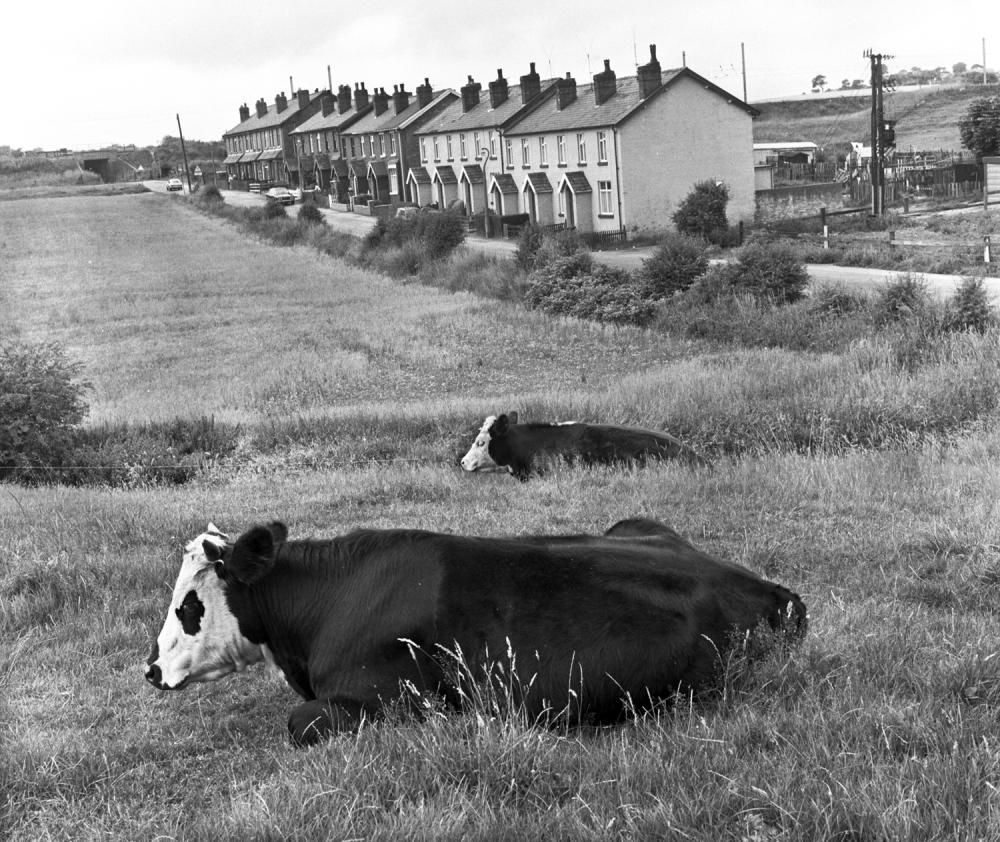
Photo: Frank Orrell
Item #: 32773
Not changed at all since then Frank, possibly the house owners have and certainly the cows, a good shot of a place i know well, i went through the railway bridge (top left) yesterday. I remember in the 40's / early 50's if it rained hard people from Bradley (The lost city) as we Standish kids called it, couldn't walk under the bridge because of flood water, fortunately a grid was put there eventually.
One of the best cycling jaunts when I was kid . All down hill from the top of Bradley Lane . Past the Mayflower works , Barber Motors . Picking up speed past the Black rook . On sunny days the light flashed through the railings of the Heinz factory almost blinding you . Freewheeling all the way . Past Carringtons then into the darkness of that tunnel in the picture. Emerging like bullets without regard for what or who was coming . Past The Colonels house . All the way to the bottom of the hil
The road from Standish to Worthington is residential Avondale Street, then industrial Bradley Lane, and finally rural Platt Lane with a low railway bridge under the west coast main line. In 1975 when this photograph was taken the line has overhead electrification.
Thankfully, one area that has hardly changed in 40 odd years.
Standish has just evolved into a housing development nightmare, but luckily the area around the Crown pub remains untouched and will hopefully remain so.
DAVE and others, do you remember the house in the centre of the tunnel between the railway lines ? A lady who worked at Carrington and Dewhurst lived there, it must have been nightmareish with the steam trains thundering past.
I can't remember that Roy , but it sounds amazing . What came first I wonder , the house or the railway ? . The thought reminds me of that farmhouse on the summit of the M62 .
Roy - what you're describing seems improbable, given the closeness of the tracks across the bridge - but Old Maps show the other bridge which carried the lines which served the Broomfield and Langtree Pits and the Bradley Works. It was situated on the other side of the tunnel from here - and there is a building shown on the map in the gap between the bridge and the tunnel.
I don't know Dave it would be interesting to find out. It doesn't seem that long ago since it was demolished. I agree with what you said earlier, these photos from Frank are brilliant.
Regarding the farm on the M62 summit a lot of folk think the farmer declined to move, but that wasn't the case, it was a civil engineering problem regarding the lie of the land.
I went in Robbies yesterday, Barry tells me you haven't 'been' there for quite a while.
Doe's anyone know if some of these houses were refurbished in the late 60s/early 70s..My husband worked on some in Standish then.Also in Fairhurst Ave.I have a photo of him in this Ave with other workers.But I will have to ask my friend to put it on here for me.I have tried but no success.
I pop in early doors Roy , for milk or a loaf . Well before our kid starts .
Hi Edna refurbished around 1970 /71 worked at both Bradley lane Hutton Street + Fairhurst Ave for Eric Ayles sadly he was killed at central park
My husband worked for Eric Ayles.He went to Central Park with Eric a couple of weeks before the accident. The tipper truck was faulty, and when Eric went again, on his own, it got stuck in the gateway.It was a terrible accident.
Edna what is your husbands name more than likely
we were on the same site
A lass in my class at school lived in one of those houses.
Rev David, i can assure you there was a house between the tracks and not that long ago either. I shall dig deeper, i know someone still living in Bradley who has been there at leas 50 years.
DAVE, i said 'been' instead of 'work' to prevent possible identification.
Roy is spot on about the railway cottages that stood between the main line and the mineral line. Jack McDermott and his family lived in one of them and i think his neighbours where the Hardy's. .Jack i believe was a guard on the railways.
The cottage was there in the 1840's before the mineral line to Langtree and Broomfield Collieries was laid, it was one of several railway cottages in Standish built to house the railway workers.
There were actually two semi detached cottages built of thick stone walls for obvious reasons, both with back gardens. McDermott's lived in one and i am told a family called Harding lived in the other, One or two of the male McDermott's worked on the railways so i presume that's why they were living there.
Roy - although I've passed through the bridges many times, I must admit I've never really thought about what I'm passing under, and you have to concentrate on your driving when passing through. Looking at Google Earth now (the camera sticking out of their survey car must have been too high to pass under the bridges - the images stop each side of the bridges, so do not show a drive through it) - I see what I've missed: that there are two bridges - the longer, main line span and the redundant span I was describing - which I thought, in my mind's eye, was no longer there. There is, as Old Maps show, room for a house on the north side, where the mineral line curves off westwards. That's perhaps what you recall.
Incidentally, the Google Earth coverage used to stop on the West side of the bridges, and didn't show anything of the East side until a bit further back - so it looked as if Bradley Lane was a dead end at the bridge. I emailed Google Earth and pointed out that this was a through-route, and was even a bus route. They seem to have taken notice.
I have images of a 1920/30s Directory which gives the railway employees living there then as Bradshaw and Hesketh.
The rows of houses shown here number from 48 to 14 - but the Directory records another five, 58-50, which once stood somewhere to the right of the cameraman.
Joseph Bradshaw and his wife Ada where living in the cottage in 1911 according to the census, his occupation is show as a "Platelayer" that's was basically track maintenance..
Between the two bridges there is a gap of about 10 yards with a low wall and a metal fence in front of it parallel with the road, a few years ago if you walked under the bridge and looked into the gap towards the top of the embankment were the remains of the cottages, now overgrown with scrub and trees.
The photographer looks like he's stood just in front of whats now the car park entrance at the Crown, near to the S bend. I remember my Mum telling me a tale of when she was little, she heard the sound of aircraft getting louder. My Grandad shouted " Gerry's coming ", then there was a very loud bang and the ground shook, to which he exclaimed " too late, he's been ". I got told a german bomber dropped a bomb in this area narrowly missing the munitions factory on the other side of the bridge. Don't know how true this is. Can anyone confirm. If true and they had have hit the factory there wouldn't have been much of Standish left
Shaun, it would appear that there were 3 cottages according to the 1911 census, all 3 head of families were platelayers, Thomas Ascroft, Joseph Curran and as you mentioned Joseph Bradshaw, their address's were, Railway Cottages, Jolly's Valley, Worthington according to the enumerator.
My records show that 14 men from this end of Bradley Lane enlisted in WW1 - six of them never returned. Quite a tally for so few houses.
WNI Standisher, it was dropped in Bentham's farmland approximately where the right angled corner is in Bentham Rd, i clearly remember my mother taking me, along with many other parents and children to look at the crater. It's not clear and never will be, whether he was aiming for the munitions site or offloading the last of his bombs on his way 'home'
Certainly is David.
Roy, i think we,ve both made a mistake with the 1911 census. The three Jolly's Valley cottages are not the one's where discussing they were near Victoria colliery.
The two cottages at Bradley where No. 12 & 14 Bradley Lane. On the 1911 census they where called Bradley Hall Railway Cottages.
Rev, is there any chance of you posting the list of Bradley men that enlisted>
shaun - What do you want - this row (plus the demolished houses)? Or, Hutton Street (which goes off at right angles to the left of the photo), plus Bradley Lane on the other side of the bridge, back up to Market Street?
I don't think, by the way, that the cottages between the bridges were numbered - 14 Bradley Lane is the first cottage up from the bridge in this pic.
Shaun - I've emailed you my file giving the names of all I could find you served in WW1.
If anyone else wants a copy, please email me.
Shaun you are correct we have made a mistake. The 1911 census shows only one family, the Orrell's, living in BHRCottages, with a son shown as a platelayer. I can't see where you get 12 and 14 from, as Rev David states no 14 is the first house under the bridge and has been as i know of for 50 years, having had connections with it. I have often wondered where 10 and 12 Bradley Lane were, i know where 2,4,6 and 8 but 10 and 12, not a clue.
One of the six killed in WW1 was James Smith. His address is given as 12 Bradley Lane on the Standish-with-Langtree Roll of Honour, now in Standish Library. It is also the address given for him in St Wilfrid's Baptism Registers for his sons' Baptisms in 1915 and 1917 - '12 Railway Cottages, Bradley Lane'. He was a platelayer for the L&Y Railway, and was in the Railway Operating Division of the Royal Engineers when killed in Palestine on August 14th 1918.
His younger son, Robert Henry, died on the Burma-Siam Railway as a Japanese PoW exactly 25 years after his father's death - August 14th 1943.
His mother was Elizabeth Banks, of 42 Bradley Lane - her brother, Robert, was also killed in WW1 - on the Somme in 1916. She remarried (another platelayer, from Coppull) in 1922.
Sorry, i should of said that the Railway cottages where numbered 10 & 12 not 12 & 14. The 1939 England and Wales Register confirms this as does the info that Rev David as come across.
Rev David thanks for the file that will save me a lot of time
I seem to remember a shop somewhere in the middle of the row of houses shown, perhaps someone who lived down Bradley might be able to confirm if there was a shop in the row of houses. Also wasn't there a signal box in between the bridges and the rail tracks mentioned.
I don't remember a shop there Ackky, there was a shop in the next row in Platt Lane, next door to the Crown.
I have 2 aerial photos of the bridge and tracks and there is no signal box showing.
Roy the signal box was close to Rectory lane bridge on the north side , also the first shop was end of the first row Under the bridge , it was Owned by the Pennington family ,the other shop was was in platt lane Worthington ,now the first house before the crown hotel , if I’m not mistook the boundaries between ,,,Bradley lane and Worthington , is Bradley Brook ,
Old Maps shows a signal box to the right of the main line bridge - so hidden by the houses.
A small building is also shown opposite the two houses between the two bridges.
The signal box A Banks mentions was between the tracks, north of Standish Station - I think you'll find a pic in the Album which shows it.
Alan, thanks for that, i know about the signal box near Rectory Lane bridge, but we are talking about a signal box between the two lines over Bradley bridge. From Rev David's comment it would appear that there was a box there. I knew the Platt Lane shop from when EA owned it and am a good friend of the lad who owns the house now.
Just for clarity, Roy - the box I referred to was to the East of the WCML, not between the tracks.
For those of you who haven't seen the old maps site I use, here's the url for its front page:
https://maps.nls.uk/geo/explore/#zoom=12&lat=51.46040&lon=-0.25700&layers=168&b=1
After clicking off the panel there, you can type in the name of wherever you're looking at, and the old map will appear (you can change the date of the maps - but the one which presents is the best scale). At the bottom of the menu box is a feature I hadn't explored until last week - it allows you to change the opacity of the image. As you move the blob to the left, the map is overlaid, bit by bit, by the present-day Google Earth image. It enables you to see exactly what was on the ground of a particular location a century or more ago.
When and why was Hutton street built. I've been told it was for Miners/colliery workers and also Mill workers.
There were cottages between the bridges. As a child in the 70s & 80s I would climb over the wall, which was a bit of an adventure. The bricks of the demolished cottages were clearly visible & I walked over them.
Kids from historic Bradley families used to tell tales of there having been a train station stop on the bridge within living memory.
Late 50's early 60's I went to the TLS school with a lad who lived here.. Lincoln Banks.