Wigan Album
BLOODY MOUNTAINS
30 Comments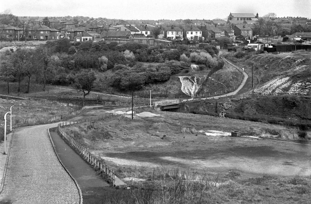
Photo: Frank Orrell
Item #: 32772
This area was the equivalent to the Theme Parks of today. In those days kids made their own entertainment from bits of wood etc. Fighting battles and shooting Red Indians.
What a good photo Ron for evoking memories of the past.I walked this way to Wigan, daily going to work in the late 70s.
In the background must be st Stephens church it looks closer in the photo also st Mary's rugby league pitch next to the duggy
Sorry,I meant to thank Frank for the photo...Its down to the brain fog!!!!
The Camel's Hump was the best adventure playground ever. Always headed there in the school holidays. Bottles of corporation pop and a butty or two kept you going! It was 'Jungle Jim ' creeping through the bushes - when we weren't roly polying down the hill.
This set of photos is amazing! Frank's photos bring back to life the Wigan we used to know.
Another wonderful pic.
I believe the houses on West Mount & Fellside were built in the 1980s.
Does anyone know what the site at the top of the hill was used for before it was redeveloped?
CJ
Precious memories Veronica, we used to take some of the childen there from our street, with pop and butties, out all day, just playing & walking.Then later I was there in my teens with my boyfriend, later my husband. Such happy times.
Coppull Lane goes from Swinley to Whelley across the River Douglas. There has been trouble here recently with youths congregating. Bradshaw Street and Whelley Hospital is visible as is the Bottling Wood estate, Chestnut Road, Walnut Avenue, Rosemary Crescent and Cedar Drive with identical houses to those in Beech Hill.
CJAllan, copy and paste the link below into your Browser Bar or do a Google search, it's a great photo that Ron put on of the area in the 1930s and you can see what was at the top of the hill and also the bottom.
https://www.wiganworld.co.uk/album/photo.php?opt=5&id=30046&gallery=Coppull+Lane&page=1
There is a housing estate now, were Whelley hospital once stood.
CJ West Mount was built in the late 50's early 60's. As kids we used to play on the building site and Jones the builder used to come back in the evenings to chase us off. The path leading down to the Duggy is Maloney's Brow and at the side of that the little jungle with the 'Devil's Cave'
When I went to St Georges School part of the Camel's hump at the rear of Pyke Street was our football playing field . Not very level as I recall. At the top of the path leading from the bridge across the river to the end of Moore St. was Winnards dairy though I imagine it would have been long gone by the time of this photograph.
Camels hump is just to the right of this photo st georges used to have a football pitch on top if you kicked the ball to hard it was down the hill. there was also a lot of pens were the pigeon men used to use
My memory (having lived in Pyke Street) was Rimmers, who used to make Jubbly the frozen triangular shaped drink, was at the end of Moore Street with the path at the side leading to Bottling Wood. Rimmers had a large concrete loading bay that we used to sit on eating our Jubblies At the top of the path at the side of it on Bradshaw lane was Brookfields shop and later on a Chippy next door. I'm talking late 50's early 60's
You are right fairpaul, it was Rimmers dairy, not Winnards as I quoted.
When I was recording the memorial plaques installed at their pits etc by the Wigan Coal and Iron Co, I came across a number of men from Victoria and Alexandra Pits who lived in Bottling Wood. There are a couple of photographs under 'Bottling Wood' in this Album which shows the houses which used to be there - mostly up to the left of the area shown.
Wigan Archives lists 16 men from there who served - many of whom died, including a number who died at Gallipoli with the 1st/5th Manchesters:
https://archives.wigan.gov.uk/search?q=Bottling+Wood&action=search
The Victoria Pit plaque is in St Wilfrid's Gate House (with a copy outside St Anne's Shevington), but the Alexandra/ Lindsay Pit plaque has disappeared.
fairpaul... I remember playing in that jungle as a kid and also the cave. Any idea as to the origin of the cave?
No Ste. don't know the origin of it but spent a lot of time playing in there and surrounding area, 89 steps leading up to Walnut Ave. Catching Newts in the pond which as you look at the photo was to the left at the bottom of Coppull Lane. Jumping in the sand pit on Camel's Hump and of course the Plantations, where we had a swing on the iron bridge.The list goes on from a brilliant era.
Fairpaul
I believe some of the houses on West Mount were built in the 1950s or 60s - however the houses close to the paddock are quite modern looking and I assume they were built about 30 odd years ago.
You can see the houses at the bottom of Bradshaw Street on this photograph. Does anyone remember there being an off licence and chippy there? The chippy was run by a lady called Josie if I remember.
CJ
Yes definitely remember Josie and her Chippy next door to Brookfields shop which I think is the most prominent building directly in front of St Stephen's Church (not in reality just in this photo) Don't recall an off licence though?
When West Mount was built it ran from the bottom of Vine Street almost right up to the area on the top right were you can see two dark wooden buildings which I think were garages for HGVs. West Mount stood alone at the side of the Camels Hump until they started to build at the back of it which if I was to guess I'd say late sixties 68/69???
Fairpaul
I apologise - I could be wrong about it being an off licence, but there was definately a shop there on Bradshaw Street. It could have been a traditional convenience store.
Parts of Whelley have changed a bit over the years. I remember the hospital and the tax offices, which are also long gone.
CJ
In the 40s the 2 shops were a general store and a chip shop owned by Pilkington's. never knew the name of the owners of the store, always referred to as the Bottom shop by Bottling Wooders.
Used to walk through Ashcroft to play football for st georges
Great picture brings back memories, I used this route every day on my motorbike from Chestnut Rd to the A49.
The land to the right of Moloneys brow was once just a slag heap, waste from Moloneys pit. The prominent building on the left belonged to Billy (Wink) Winstanley and sat atop the 'Devils cave'
in the 'little jungle'. Bill acquired the slag heap and started to rear pigs, he later rented the land to accommodate garages for the newly motorised Bottling Wooders. Bill repeated this project when he bought the slag heap in Scot Lane, Blackrod, and again built a bungalow on top of what was the railway bridge over the road, he rented the site which now an industrial estate.
As a lad the 'Bottom Shop' was Mrs Fishwicks the chip shop wasn't in use.
The dairy at the bottom of Moore St. started making ice cream I guess somewhere around 1950 and you could knock on the door of the house where they lived next door and buy a Fairy ice.
I used to work at Whelley Hospital,one night I had to rush to RAEI,in an emergency..I ran all the way through the Bloody Mountains but was so glad to reach the RAEI,I had a very uneasy feeling all the way through there,then someone told me the history of the place..I do seem to pick up on certain areas,so I hope I never have to go that way again.
The name Bloody Mountains predates the Civil War. There is a hill near the Haigh plantation gates called Bloody Hill. The name reputedly predates the establishment of Coccium and the construction of the Roman Road. During the Roman invasion, their legions would have been obliged to advance up the old cart track to Standish. They reputedly engaged the local Britons at Bloody Hill; our defeated troops were able to scatter into the woods to the NE, Sennicar Woods. Prior to the 1950s open cast in the Whelley Basin, Sennicar Woods extended between the former railway and the canal - a rump of the woods remains by the Wigan Rugby Union Club. After WW1 this part of the Haigh Estate passed to Tom Blackburn of Rothwells Farm (off Senecar Lane). Sennicar is a mapmakers corruption of Senecar. The Roman philosopher Seneca died AD65, about when the battle may have taken place. Conquerors name places and it is usually those names that survive. Draw your own conclusions.
Information derived from stories by my grandfather Tom Blackburn (Rothwells Farm c1920-1970)
Hi there, my Alkers lived at rothwells farm, also brock mill farm, about 1855? Have you any information about rothwells?
The general store was Brook fields. Think it was owned by Isabel with sons Tony and Martin (Sam) and daughter Babs. Anyone remember the shop in Moore St near Pyke St where you could buy ha'penny Spanish and kali?
Loved everyone's contribution to this but Paul Winters article fascinating..
I remember the Bloody Mountain very well and playing around there in the 1950's and Early 60's. I remember that cave also and would like to know its origins.
Does anyone remember an area of very smooth polished rock, very soft to touch? I am not one given to fantasy but saw a program recently on National Geographic from California, similar polished rock faces were created by Mammoths or Mastodons rubbing against them, could they have roamed up the Douglas Valley (I think earlier called the Aslan River but not from the Lion Witch and the Wardrobe)) be that the cave was made by stone age people????
Back to more recent times, Miss Prior from St John's School, Brick Kiln Lane took our class up there for a game of football ( (the kicking version) one of my class mates did not understand the rules, picked up the ball and ran into the goal mouth of two coats and made the touch down. He was both bewildered and humiliated, don't thing the game was finished and we all walked back laughing. Poor lad, I know his name but would never divulge (not without a fee anyway!!!!!)
Someone mentioned the name Rimmer, I remember a very pretty girl with blond hair at St John's School, I think her name was Christine but not too sure. Being quite a young gentleman (still am) after school I walked her across the Camels Hump towards Bottling Wood to meet her mum at work in that vicinity, I thought it was a Laundry but could have been a dairy. Does anyone know???