Wigan Album
Standish
10 Comments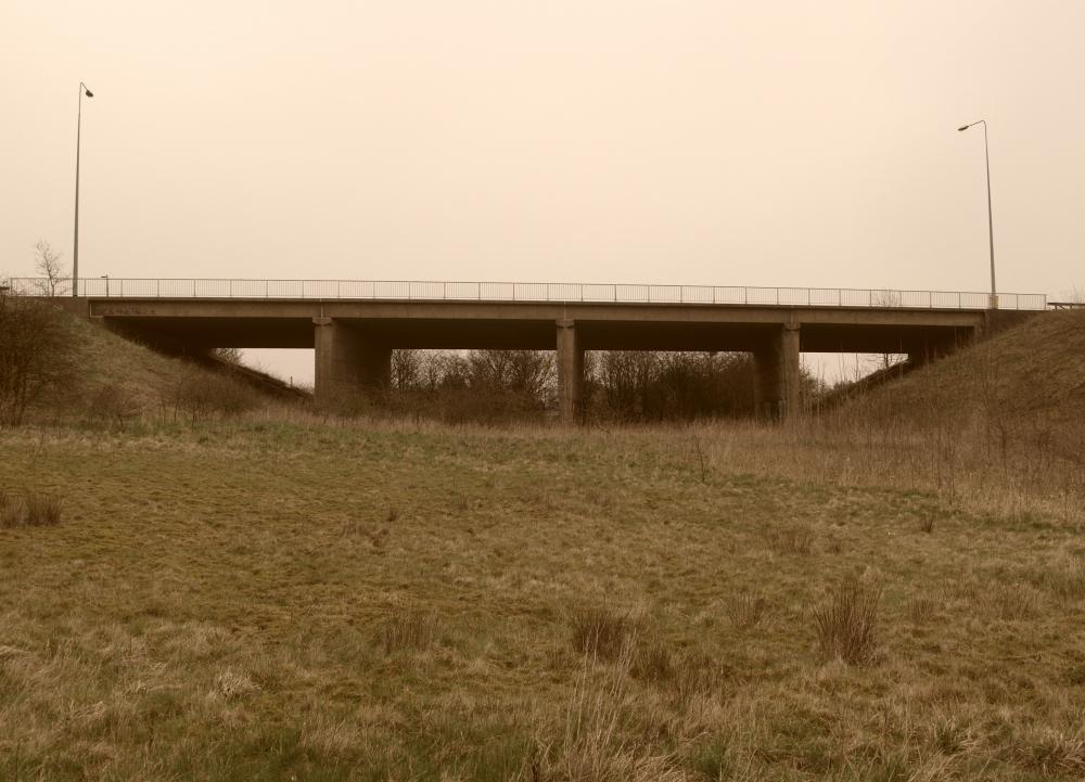
Photo: Harry Gardner
Item #: 20273
The bridge carries shevington lane over what is an empty piece of land & the photo is taken from where a dual carriageway should have been.
Apparantly this would have been where the Wigan Northern Link Road would have run underneath shevington lane to provide a dual carriageway link from around the Woodhouse Drive/Martland mill Area direct to the M6 at Junction 27 at Standish.
In the early 1960s when the M6 (& Jct 27) was constructed this bridge was also constructed nearby for a future road that was planned but never came to be.
The bridge obvioisly still stands & of course is still used by traffic above but it just spans an empty unused void.
A monument to a link road for Wigan that never was.
True Harry, and just one of the many planned new roads for Wigan that have never come to fruition, wonder if the plans are still gathering dust in some archives or have they long been been binned.
Aren't you glad it never was built? Let's keep the Greenbelt for posterity, eh?
It would have saved Standish from being clogged up with traffic,[especially artics]for the last 40 odd years!
My brother in law worked on creating this and he said it was meant to be for a road link round Standish to Boars Head.
I agree with Frank. I heard it was meant to be a by-pass for Standish.
The road was going to go past the back of St Maries church, through the fields and come out near the Boars Head pub.
One of those fields is near my house, so I'm glad it didn't get built.
N.I.M.B.Y.
Frank is corect as far as remeber. The link road would have connected to the A49 just north of the Boars Head where the entrance to the Gildlow Cemetery is. if it had been built y it could certainly have helped with the nightmare of getting through Standish in the rush hour, not to mention saving a few lives that have been lost as as a result of our blessed Local Government inactivity. Has anyone notice how money could suddenly be found to surface the car parks near to the Life Centre now that our Council Officers have to park there?
There may have been a link to Boars head, but as Harry's said, there were definitely plans for it to come down to Martland - it then split; a road to the Heinz factory and a road that would widen Woodhouse lane to become a dual carriage way.
My Dad saw the plans in 1964 when he bought his house just off Woodhouse Lane - all the terraced houses were to be demolished. His choice of house was on the basis of this and it never happened...
From what i got told some years ago there was indeed another spur of this link road also planned (stage 2),that would have branched off near to Stockley Hill Wood & on to Boars Head,with the main Wigan Northern Link road continuing round the back of Elnup Wood,Birley Wood,Crooke & Standish Lower Ground to meet up with Woodhouse Drive somewhere near Mayalls .
I was told thats why there were also three new bridges built to carry the new route of Scot Lane in the 1960s.
These new bridges carry Scot Lane over. .
The Leeds & Liverpool Canal.
The River Douglas.
& the last bridge carries The Wigan To Southport Railway over Scot Lane.
All were constructed at Martland Mill as advance works for this Wigan Northern Link Road that never came off.
No doubt it would taken many lorries off the road,but no doubt that it would have also opened up many acres of land for the developers to build on.
During the 1960's this was our football field, cricket pitch, pitch n put course, and when it snowed we usd to slide down the sides on old car bonnets, , spent many an hour during school holidsys and week ends playing here. Us kids always knew it as the middle of the motorway!!
What greenbelt would that be? Standish is ruined.