Wigan Album
Birkett Bank
16 Comments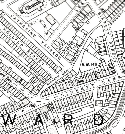
Photo: Keith
Item #: 22395
Keith - Great Map. I was born in Birkett Bank Terrace in 1949 and I don't know where the Raven pub was but I do remember there was a gap in the houses on the same side as the Crispin where it could have been. The building you have marked on the photograph as the raven wasn't a pub when I lived there. It could have been a shop.
Were did the bomb fall in Harper St would that be round about Ingalwood Av. My grandmother lived at 19 Harper st she was Mrs Fillingham her father died in Harper St at number 21 his name was Hodkinson in 1915 this was the end house as I remember it.I don't know when my grandmother moved to Harper St but I have the feeling she moved to her fathers house after he died if this is so were the houses renumberd
It's an interesting map. Bearing in mind the context in which it is being discussed, I note that Scholefield Lane isn't named on the map. Instead something like "ard Bdy" appears instead. I presume that stands for "Ward boundary" but, whatever it stands for, that's where Scholefield Lane is.
Ken. Wasn't Harper Street,down a side street,on the right hand side of Darlington Street, going towards "English Tools Factory"? As far as I remember, it faced a lot of open land, until you reached the canal. I had an uncle that lived in Harper Street.
My mam was born in Harper Street in 1915,and she was told by a neighbour that they remember seeing her crawl from under the table after a bomb dropped...I don't know what number she lived at...something else I wish I'd asked while she was still alive.
maureen have you not got your mothers birth cert that may tell you what number.
My great grandparents lived in the Raven at no/29 Birkett Bank from 1889/1930s and the map with INN on it will be the Raven.
Quite right John, ScholefieldLlane is exactly where you've identified it I believe, but because of the camera angle it seems ridiculously narrow. I do wonder now that the "pub" identified by the author could have been the Black Bull, as mentioned by AB, situated not in Scholefield Lane but in Hardybutts. Access to the 1901 Census should help identify it even though it closed in 1906 and perhaps that's why on the map it doesn't have the word "Inn". If this pub was demolished it would have also "opened up" the end of Scholefield Lane, just a thought. The 4 or 5 people in the photo appear to be standing in Birkett Bank Terrace but are surrounded by the ends and sides of houses rather than the actual houses in the Terrace, they are further down and as far as this photo goes, out of sight.
No Len I'm afraid I haven't.
You had to go down Ingalwood Av to get Harper St the houses were back to back with Darlington St with the back yards inbetween and an alley which we called the backalley
Keith - the Black Bull is in Hardybutts, where the number - I think the Raven must be the square near the number 166 and as you say when it was demolished it opened the area up. You are also right the terraced cottages of Birkett Bank Terrace are behind the building at the end of Catherine Terrace. There must have been an Inn at the bottom to the steps just above the K in Birkett Bank - it was an open space with advertising hoardings in front in the late 40s and 50s - we used to play behind them.
Thanks Maggie K, for your input and to everyone who have made contributions, as far as I'm concerned it brings the area to life again, nearly 100 years later.
Maggie,,
we used to refer to the area behind the advertising hoardings as "the old alehouse"and was an adventure playground for us from Birkett Bank and Bibbys Backs Area...manys the hour we have spent in there,,,
Jim - on the map it shows where the hoardings were as an Inn so that is probably why they called it the old ale house. Keith has put more photographs on and one shows what he thinks is the old Lodging House in Birkett Bank Terrace - I think it is. Do you know anything about the house. It was a very nice detached house - I wonder who it was built for?
Maggie..
i dont think it is..i think its the last small block houses in Leader St, viewed from the back ,,think the "Lodging House" was more to the right and it was a less imposing building.
You could be right Jim.