Wigan Album
W.R.DEAKIN JAM WORKS
13 Comments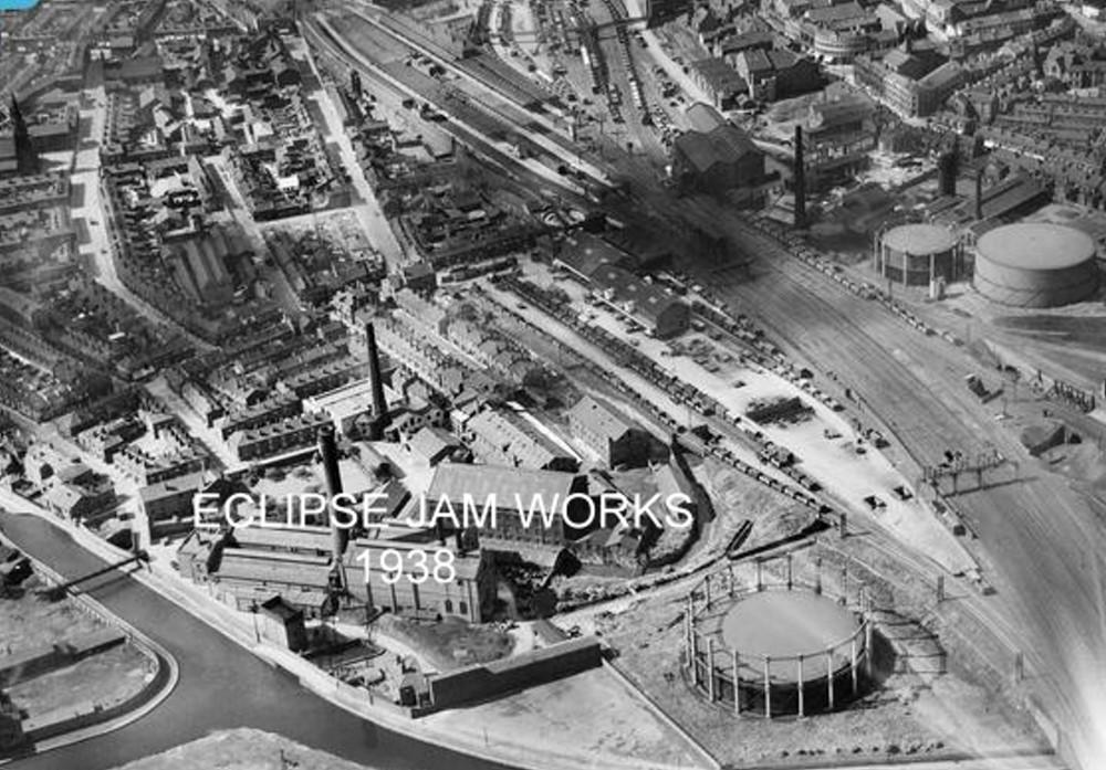
Photo: RON HUNT
Item #: 28213
ere is a link to the company information and the people who owned it
http://www.deakin.broadwaymanor.co.uk/deakin/deakin-jam-history.html
Thanks to Philip Gormley for sending me the info.
To who published this photo which is superb could anyone throw some light on it's whereabouts i have been scanning it for ages but it has got me flummoxed. hope you can help. But again these photo's of old wigan are fantasic.
Looks like Wallgate (top left)and Caroline St., Queen St. and Chapel Lane. Leeds Lpl. canal (bottom Left).
Alan, bottom left is the start of the Leigh Branch of the Leeds/Liverpool Canal, railway line top centre to bottom right is the main West Coast line, top left running down to centre left is Caroline Street, with the old St Thomas's spire on the left edge near the top. Enough to get you your bearings?
Alan. In the centre where the line divides, to the right it goes into Wallgate Rly Station, and to the left to Wigan N.W. It looks like the iron bridge, further along from where the left divides. In the fifties there was a jam works in Queen Street, or the remnants of one. I could never make out as to whether it was a going concern, or not. On the other side, below the railway, there were a number of types of warehouses. All well secured.
I remember Deakins jam works my Mam used to work there, when it was the Queen's Coronation we had a street party there. To give you an idea of where it was Bradford Place was on the left at the bottom of Bradford Street, Bradford Street is still there just off Chapel Lane.
Alan - You might also like to search Google for 'Britain from Above Deakin's Eclipse', where you'll find other pin-pointed locations.
Anne. Is Bradford Street anywhere near Queen Street, as you go towards Chapel Lane? It is so long ago that I was in that area, that my bearings may be somewhat mixed up. I remember it mentioned something about jam products on the window pane. It did look derelict. This would be 1958/59.
Under this lot (and still is) is the River Douglas It went into a tunnel by the gasometer in Darlington St went under the Gas works, the main railway line ,the works in bradford place and the canal, and surfaced in Chapel lane by Fosters funiture works
What I want to know is where the Jam Butty mines were located.
End of King Street, old town hall and Wigan Hippodrome and Darlington Street are just visible near top right of photo.
Albert, Bradford St. is on opposite side of road to Queen St. further down almost opposite Bear's Paw. The other jam works was in Princess St. (opposite St. Thomas' Labour Club)
it was called Mawdesley's
I think the site is now occupied by DELMO car breakers.
Delmo's Site Was Called Eclipse Works.Looking At The Curve In The Canal. I Would Say This Was On Bradford Street Off Chapel Lane