Wigan Album
Railways
18 Comments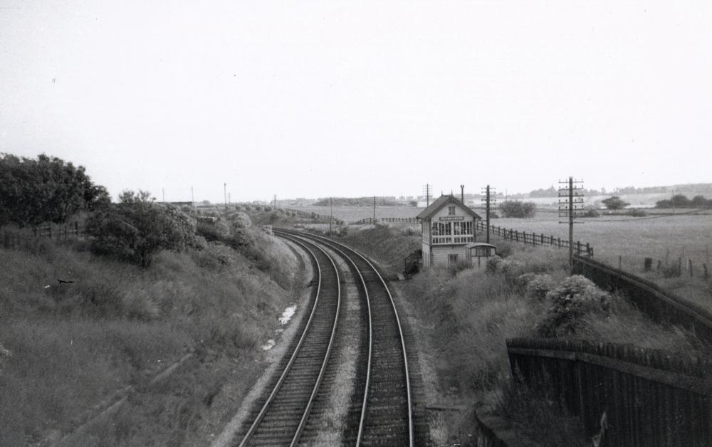
Photo: Harry Gardner
Item #: 15453
There was once a station at this point but it closed (along with dicconson lane & aspull station in february 1954),& was demolished along with the platforms by the mid 60s.
The line from horwich fork junction to crow nest & dobb brow junctions lingered on for a few years but was closed completely in september 1968 & was lifted soon after.
The site & cutting in this photo has now been filled in up to road level,with a garden centre (baxters nurseries)now occupying the site.
Nice one Harry, I have a piccy of the station before closure which I will put on soon. Another good picture of yet another destroyed piece of railway. We had the best railway system in the World only to see it destroyed and hamstrung by duplicitious politicians, who desired to promote private road transport over public transport ie the railway. How we need to see the political will exercised to re-open many of these closed lines again instead of throwing money at the roads all the time. dave
A few years back, I remember parking the car up near the site of Dicconson Lane station and walking the line to Hilton House.
The reason for the walk was to find the site of Brinsop Hall Coll which was sunk at the side of this line.
The engine beds that supported the winding engine were still there.
Dave; I have a photo of Hilton House station looking towards the A6 where the hotel is now, the building to the right of the former bridge used to be a pub, but I can't remember the name.
Harry; Thanks for the pic, were you a railwayman at one time?
Great information Harry, Dave and Winder. You,re absolutely right, our railways have been destroyed by Politicians especially the branch lines. As soon as you leave home in a car it's not long before your in a traffic jam, some of these closed lines could be of good service today. Has there ever been a closed line re-opened? I can't think of any, only ones thats been proposed the likes of Leigh. Road Transport has got to be a worry and can only get worse.
Lovely photo Harry.
The powers that be (who ever they are) thought, "making more motorways would solve the traffic problems", but like all politicians their WRONG. Surely with today's technology and machinery and the right politicians making or reopening railway lines is worth considering.
The following was written by Denis Sweeney in his book A Lancashire Triangle in 1996.
The rising ascendancy of motor transport and its "convenience factor" which, with continued government support for road building schemes above all else for some forty years, along with a total lack of any co-ordinated transport policy, merely compounded the problem. Only now is the folly of this begining to dawn on some of our political leaders, too late however for many of our local lines.
Hi Winder,I am an ex railwayman,(signalman).
Will you ever be featuring this line & colliery area in one of your future DVDs Cliff??.
Hello Harry.
ALL the abandoned lines around the Wigan Borough were planned to be "Uncovered". I have Part Three, Red Rock to White Bear and Lord Crawfords mineral line from Grimeford siding through to Haigh Foundry and Brock Mill Forge, already in the camera, but need a new edit suite as my old one is burgered!
I plan to get the web site up to date very shortly so I will let you know any developments on there
hi winder,Brinks pit in the aberdeen area between adlington & blackrod was served by crawfords mineral railway network wasnt it?,or have i got my wires crossed?,someone once told me that a lot of that area was subjected to later invasive opencast workings in the 50s/60s & it removed a lot of previous evidence of earthworkings etc (along with some houses too).
A lot of the farmland around aberdeen & on the hillsides towards blackrod seem somewhat "sterile" & man made to me.
Yes, your right, Harry, the fields arounds Brinks and Aberdeen Colls were opencasted in the early 60s, I have seen an aeriel photo that area when they were doing it.
If the link works, this is a map of Brinks abbout 100 yrs ago.
http://img524.imageshack.us/img524/6167/aberdeenandbrinksmapms0.jpg
It does, and good stuff Harry and Winder, never even heard of Brinks' colliery before. Dave
Thanks Winder.
When was British Rail privatized and why was that? be very interesting to know...
The process started in about 1994 with the formation of Railtrack which was the company that was created to become the owner of the railway infrastructure, track, signalling equipment, overhead and third rail traction equipment, mechanical and electrical plant etc, etc. from BR.
Arguably though, those who were around in 1992 will recall a re-organisation of BR into four BPC's (business profit centres!!!)ie Provinicial [later to become Regional Railways], InterCity, NSE [Network South East] and [I think] Railfreight (the freight operator.)This it may be sucessfully argued I feel, was BR being ordered to put its own house onto a pre-privatisation footing which would help create the groundwork to enable the privatisation process once it started in earnest to be carried out more easily. The reasons for privatisation - well really that all depends on whether or not you think a major public transport system should be in public hands or private; and of course reasonably enough that can only be a personal observation for each of us!
Winder - looking forward to that part 3 DVD covering Grimeford etc...
Also, I've been playing with google Maps and their aerial photos. It lets you annotate the aerial photos, so you can mark pits and railways on it. I'm thinking of doing this for my Blackrod website, but something like that might be useful for yours too... Drop me a line and I'll show you what I've done so far.
Great image, in 1968 I was a Signalman at Horwich Fork Junction and on duty on the Saturday night the branch closed.The last train was the Saturday night Manchester to Aberdeen postal train.
Re Comment by: winder on 6th August 2010 at 19:14
Would like to see the old map and also your picture of the opencast. We think my wife's ancestors lived on the site of the old Aberdeen Farm (not the present one) which was probably one of the houses removed / abandonned due to the opencast. It was along a track from the Aberdeen Bridge over the canal, over the railway, some way to the North of the new Aberdeen Farm.
Best wishes, Chris
I am walking a lot of the old rail routes & coal mines. Along Rotary Way/Aberdeen Farm is site of Brinks Colliery & disturbed ground along the canal that old maps show as a Boatmans Arms (BH..Boarding house?) I look at North Mines Research Soc site but it does not have some of the older/smaller mines around Wigan, like Brinks. I tried the link but couldnt see the photos. NLS (Scotland) is good place for the older maps online.
Message for Chris Hampson,
Here is a link to the old maps that will show your old ancestral farm & what is on the site today.
maps.nls.uk/geo/explore/side-by-side/#zoom=16.5&lat=53.60033&lon=-2.60885&layers=168&right=ESRIWorld
Have a play about on the site, you can zoom in and out, have old & new maps side by side or have an overlay/overview with the new maps on top of the old ones with the old map showing through on to the new view.
The original Aberdeen Farm was directly opposite Brinks Siding signal box,
The new Aberdeen Farm is built just a few yards South West of the original Brinks Colliery.
You can really see just how the 1950s opencast pit really altered the topography of the land in that particular area.