Photos of Wigan
Photos of Wigan
Album Contents
Album Contents
Wigan Album
Wigan
4 Comments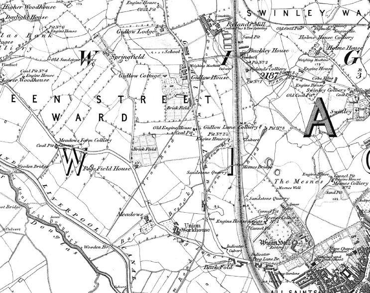
6 inch Map - Wigan Late 1840s
Photo: Mick
Photo: Mick
Views: 2,653
Item #: 22501
Item #: 22501
Further to Liam's query on the 1843 OS Map picture:-
Extract from 6 inch map of similar vintage, showing tramways in Frog Lane/Springfield areas.
Extract from 6 inch map of similar vintage, showing tramways in Frog Lane/Springfield areas.
Comment by: tony k on 20th January 2013 at 18:56
thank you for the old map i like all the maps of wigan
Comment by: liam on 20th January 2013 at 21:25
Thanks for that very clear map,i live in this area and am intrested.looks as mesnes bridge was built for a tram way to pass under and not for park road.cheers
Comment by: Carol on 23rd January 2013 at 13:24
Thanks for the map. I've just compared it to today's google map and the 1908 one I have for the area. It's helped to identify the bridge where the wife of my gt gt uncle threw herself into the Leeds Liverpool canal (whilst intoxicated) and drowned in 1907. It's the wooden bridge towards the bottom of the map. In the coroners report it is a footbridge (the White bridge) next to a turnbridge. Not far from where the footbridge is today.
Comment by: liam on 12th February 2014 at 21:10
Any ideas what black fold could have been
Leave a comment?