Wigan Album
*UNKNOWN* - Can You Help?
9 Comments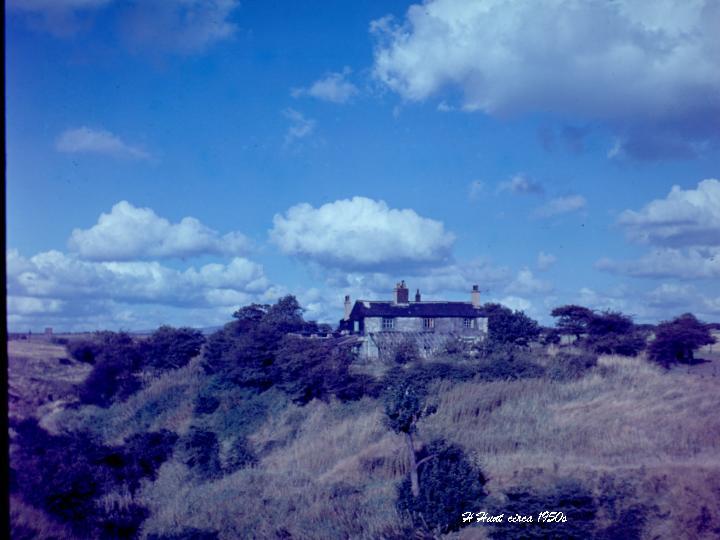
Photo: dk
Item #: 5346
dk
this is the house i have mentioned before where we lived when i was a baby/toddler. Hindley hall is to the right of the picture out of view. the farm was called bank top "peggy spout".
Well Pamker, I cawn't speyk. What a coincidence! I've been looking at this picture for ages trying to place it. Actually, I thought that the brick tower in left distance to be a pit head that used to be on this side of the road leading to Hindley Station where Hindley Deep Pit would be on the other side but I'm afraid I'm still not sure. What's your mapmaking skills like? I'd be really pleased if you could pinpoint it. And, I suppose it's gone now? Many thanks anyway.
dk
I have got an old map of the area and will dig it out A.S.A.P. It shows exactly where bank top farm is or was. Am pretty sure its still there but will have a walk up there to check and maybe get a photo from where this ones taken. watch this space.
Well, I think I've got you now. Up through the Hemfield Road slag heaps and on through the field - so I was a good mile away before around DeTrafford Junction. This would put the Delph a bit further on, with the brook - is it Ince Brook - running through this wooded valley before disappearing underground. Were there other buildings situated behind it from here? I remember a white farmhouse up on the hill looking from the golf course side with the corner of its wheat field nearly touching the course - we would root around in it looking for golfballs and the farmer was never too chuffed. We avoided going up his lane.
This puts the brick building, whatever it is, towards Withington Lane. Does this sound right? You'll have to forgive me I was only six.
spot on dk, we walked through the delph to get to the house,
The houses you can see on the horizon to the left , I think was called Jollies row which was in fact part of withington lane. the pit head was right behind these houses. there was a couple of houses close by called bank houses. and There was another farm further back down the path leading to John Englands towards hemfield rd.Will still dig out the map though and try and put it on album.
just come across this pic... been trying to find any pics of or near peggys spout delph...an area of particular interest as my great grandad william Jones (59)was found drowned there 02/08/1932..its states on the death cert its off withington lane...but I presume the land now is very much different to what it was in the 30's..If anyone has any info pics or maps I would truly love to know....please get in touch :)
hi trudi. the land there has not changed at all. its exactly the same now as when i was a kid. The brook is still there running down the side of the farmhouse and I am sure its even the same tree we used to swing across the brook from on our homemade swing.
was up there the other day and its not changed at all
looks like the farm in farm lane new springs ,Redland tiles factory is to the right now and the mount houseing estate on the left, holy family church on the skline on the left.
my mother aunty and uncle lived in this house when they was children. my mother was born in 1918 and lived there untill she got married when she was 20.