Wigan Album
Early Map of Wigan 1712
31 Comments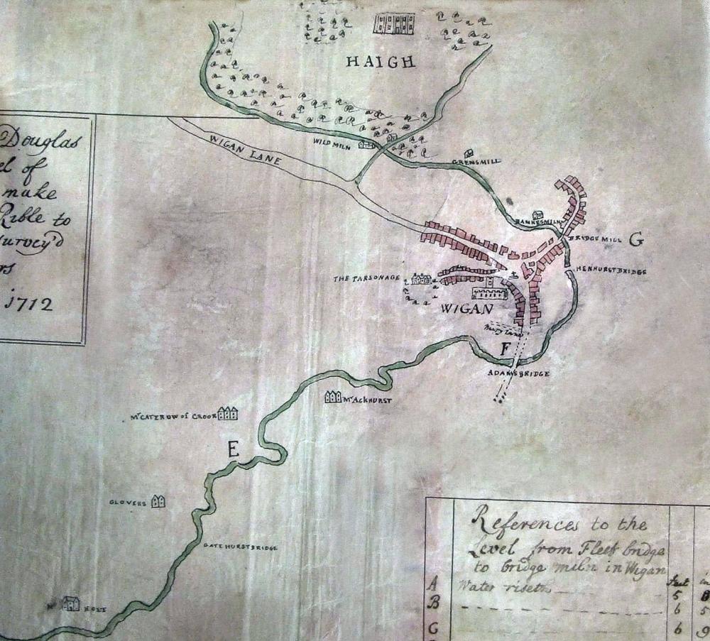
Photo: RON HUNT
Item #: 35101
Mabs Cross shown on the curve of Wigan Lane,
Peter If you are referring to the cross in the town centre? I presume that's the Town cross which was located in the Market Place. I didnt realise MIRY LANE was of such significance?
I was thinking the same about Miry Lane as well Ron.
The map makes Wigan looks no more than a village.
Although the map is naively drawn and lacking in detail it gives a insight into how small Wigan was in those days, as perhaps were all towns and many cities before the industrial revolution set in.
Little more than a road through the town through Wallagate, Standishgate and Wigan Lane with Hallgate, The Wiend and Millgate branching off.
Turning off Wigan lane to the right could that be Coppull Lane, prior to access to the Haigh Estate being via the Plantation Gates?
Excellent Ron, love it.
In the 1700s there would probably only have been Miry Lane there. Caroline Street, Queen Street and the myriad streets which later housed the much-loved Wallgate Community just wouldn't have existed in 1712.
Ron. Mabs Cross was a waymarker cross from the 13th century and i would have thought it would appear on any of the earliest maps.
At the bottom of Wigan Lane the road turning left would that have been what became Powell St/ Greenough St lined with buildings - then curving round to Scholes/ Whelley? It’s very intriguing.
Peter - this map was surveyed by Thomas Steers - builder of the world's first commercial dock, in Liverpool - to provide the basis for converting the Douglas for commercial navigation. The main supporter he wished to enlist for the enterprise was Sir Roger Bradshaigh of Haigh Hall (and a Wigan MP), whose land was rich in cannel coal which would sell well in growing Liverpool, to which it could be conveyed round the coast via the Douglas and the Ribble. I think that's why Haigh Hall figures so prominently - and why he extended his map to demonstrate the proximity of Sir Roger's lands to the proposed navigation, and how it might be accessed.
As such, the inclusion of other features was incidental. Mab's Cross may have been of interest to someone creating a map showing the roads of the district, but it obviously didn't strike Steers as adding to the value of his survey. I reckon, had it been included, it would appear just above where the housing ends on Wigan Lane.
Colin - it may appear rough and ready - but Steers calculated the rises in water level at seven points between Rufford and Bridge Mill to the nearest half-inch - and I would expect every bend and bridge to be exactly where he marked it to be.
Opposition in Parliament to the navigation delayed its passage until 1720, despite the wide support it received in the region.
The cross seems to indicate the Moot Hall which pretty much stood there. There was a cross at the front of the building.
Wigan was of secondary importance to this mapmaker, who was actually charting and surveying the course of the River Douglas, prior to the creation of the Douglas Navigation, so it's highly likely he just showed the location, and 'basics' of the town centre, rather than detailing small allleys and yards which would have been off the main streets.
Tony L, I agree and we should not see this map as the Market place. We should view it from the river, with Coppul Lane top right and curving down to Darlington Street. If you look across to the left from the river you can see where you are in the town centre which of course would have been completely different to present. The Cross is just south of Coppull Lane and the Parish Church is level with the Darlington Street area.
Colin, you said "Although the map is naively drawn and lacking in detail it gives a insight into how small Wigan was in those days", which really is a 'naive' statement in itself. Wigan is exactly the same size now as it has always been only more built-up.
Ron - something to put on your "wants" list: the Douglas Navigation project got caught up in the South Sea Bubble financial scandals. Its shares went from £5 to £70 in a few weeks - then dropped dramatically to 3 guineas! Sets of playing cards were produced to 'commemorate' the events - and the cards in one set each featured a company being promoted at the time... and the Douglas Navigation appeared as the Ace of Spades. The face side featured an engraving showing work on the navigation and the following verse:
Since bubbles came in vogue, new arts are found/ To cut thro' rocks and level rising ground,/ That murmuring waters may be made more deep/ To drown the knave and let folks as asleep.
This and other upsets meant the Navigation was only finished in 1741.
(Information from Mike Clarke's 2016 edition of The Leeds and Liverpool Canal.)
Rev, long I would fully agree with your assessment, the map surely focuses on the route of the River Douglas as a guide to the possibilities of water born transport and access points rather than the various properties themselves. Quite likely it came in very useful when eventually planning the route of the canals.
George I am a little bit bemused after looking at the map about your comments concerning the size of Wigan. Unless you are saying that “outlying “ areas eg Hindley are not to be included as part of Wigan
George, I think you misunderstand the concept of 'naively drawn' and you are quite misguided to think so. The map is purely indicative of the rivers route and indeed the various properties and streets that existed.
For instance what is shown as Hallgate leading down to The Parsonage is not accurate in the least, it shows it running directly through what would become Market Street in the late 1800's
George I am a little bit bemused after looking at the map about your comments concerning the size of Wigan. Unless you are saying that “outlying “ areas eg Hindley are not to be included as part of Wigan
Peter Walsh, with the greatest respect, Darlington Street is nowhere near Coppull Lane, it is a continuation of the yet to be built King Street after crossing Chapel Lane and eventually leading to Darlington Street East, Higher Ince and George's beloved Hindley.
Bridge Mill is where lower Millgate crosses the river to then ascend Scholes.
Henhurst Bridge crosses the river down Chapel Lane near to where The Range now is.
Adam Bridge is down Wallgate near Asda.
I thought Bridgemill would have been the bridge crossing what would become Greenough St were the urinals where 2 centuries later.
Bridge Mill was in the location of Scholes Bridge. The road leading to it is Millgate
Where the urinals were .
I think I’ve caught the bug off Mick with his there, theirs and there’s- only mine are where, were and we’re . God help me!
Actually there’s two where’s of looking at it.
Philip Cunliffe, if Hindley was Wigan it wouldn't be called Hindley.
I'll have a pint of what Peter Walsh is drinking.
I’m sorry to butt in again. I know the course of the river was changed in the 1750’s. Did a bridge not exist at all in what would become Greenough St? On the map it would have only been a tiny space from Bridge Mill if there was. ( Excuse me whilst I get my spade from the shed) I’m thinking now there wouldn’t have been because Thomas Speers would have mentioned it - unless it was a rickety wooden bridge. The river at that point was really fast flowing if I remember in the fifties/ sixties. It sounds like I’m really off course now..just ignore me. Unless there’s a map I can pore over after all the work was done. Apologies anyway but I am interested. ( I think I have talked myself into there not being a bridge just before Bridge Mill!)
George . It’s difficult to put a point across in text without appearing too argumentative. I agree that people will proudly say I’m from Standish, Hindley etc and we are near to Wigan. That is the point I think you were putting across.
However looking at today’s map it cannot be argued that the influence of Wigan has spread beyond the confines of the map
Philip, could it not be said that the influence of beyond the confines of the map has spread into Wigan?
Ray, I will buy you a pint of John Smiths anytime. I was using the river as a scale to measure distances and positions in the town centre. I would consider the river accurate after Tony L's comment. The map should be turned 45 degrees clockwise first.
So why exactly should that area be an influence on what happened in Wigan town George (Hindleg), because the areas beyond the confines of the map didn't exist in any much form at all during this time, and actually where Hindley now is was then just a place that the muck or night soil collection carts would be emptied, and I very much doubt that the good people of Wigan town would want any influence such as that spreading in from beyond the confines of the map.