Wigan Album
Railway
8 Comments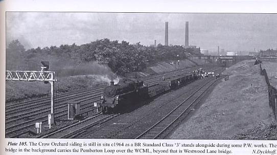
Photo: charnock
Item #: 14353
This is never Pemberton Mr Charnock. At a guess, I'd say it was taken from Springs Branch looking towards Westwood.
Isn't this a photo of the main line track at Lower Ince and not Pemberton, the bridge in the distance is the one that was between the Cemeteries isn't it, then there was another bridge on the same line going over Warrington Road near Laycocks.
Crow Orchard Terrace is Ince, Wigan. WN34QL. Go to that location on google maps and it gives it as Pemberton. I suspect this is Ince, but have mentioned Pemberton as it is already on the caption. Also cannot locate Crow Orchard Sidings on any map, so always pleased to read any comments with regard to exact position.
Crow Orchard was where the Health Centre is now on Phoenix Way Lower Ince.
Mr Charnock, if you would like to locate the Crow Orchard Siding. It is on the right of the track near to the locomotive and extends as far as A573 Warrington Road (Hilton Street), although it has all gone today. If you send me your address, I will send you a map.
A birth certifcate for my gg grandfather in 1859 locates Crow Orchard as off Ince Hall Lane
Crow Orchard terrace stood off Wilding Street at the bottom of Ince Green Lane; my friend's Auntie lived there.
The last evidence of the Crow Orchard Branch, a section of track left in the road surface of Westwood Lane, was taken up only a couple of years ago. The line was very old, serving pits north of Westwood Lane - the concrete pyramid over one shaft lies between Deakin Street and Banner Street. The line passed under an iron footbridge soon after leaving the main line, then passed behind Ince Cemetery, under the Pemberton Loop Line, in front of Eaton Terrace, split by Westwood Lane. It stayed in use after the pits closed, fetching coal in the other direction to a land sales yard beside Warrington Road - where the pensioners' bungalows in Winstanley Place now stand. No pics of the branch beyond the point shown have yet come to light....