Wigan Album
Jackson family of Hindley.
19 Comments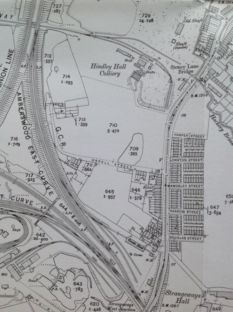
Photo: . Ozymandias .
Item #: 29737
This area was known as the Lump.I lived in Mawdsley st in the 50/60's.I do not recall anyone mentioning a De Traffotd farm but it was probably well gone by then.The pits had also gone but we used to play around the ruins of the pit, the two shafts had been filled in with pit dirt which had sunk down about fifteen feet.People used to mention a place called Owd Harry's which was down from Orrell street.Could this be DeTrafford farm?The area in my time was mainly pit rucks and was the tip area for Hindley,both domestic and industrial waste.The area 712 on the map was a pond and was filled in with rubbish as was 714 on the map.Most of this area was was then used as a tip.Sounds like a miserable place to have lived but as kids it was an adventure play ground
De Trafford farm is next to Morrisons store. At the side of the disused railway track, Hence De Trafford Junction.
Alex. I would have expected De Trafford farm to be in the area you mention.Is there still a farm by that name.?
Ozymandias: Seems your interesting contribution with reference to the De Trafford Farm is more likely to be correct. Evidently the location of the De Trafford Farm appears to have been off Liverpool Rd Hindley and not near Morrisons in Ince. Record of Marriage: 17 Oct 1931 St Peter, Hindley, Lancs.
John Jackson - 30 Haulage Hand Bachelor of 8 Gilbert St. Hindley
Mary Ethel Wilson - 25 Spinster of De Trafford Farm, Liverpool Rd. Hindley
Looks like the farm was in that area.
Page 695 - 25th May 1874. Went to Croston with the purpose of asking Mr de Trafford if he would sell a portion of the Strangeways Estate in Hindley which I wish to purchase andpresent to the people of Hindley for a park or recreation ground. the portion of the estate wanted lies between the south boundary of the Grange estate and the occupation leading to the Lowe Hall and is 14 statute acres in extent.
Page 696 - 20th June 1874. Mr de Trafford is willing to sell the land and i have arranged for the purchase of it, subject however to the Strangeways Hall Coal Comapny and Messrs Paerson & Knowles surrendering certain surface priveleges they posess by virtue of their coal leases.
http://tinyurl.com/ybyp7uod
This farm had existed since before 1822 as it is shown on the map of that time. It was never named as such on any map I have seen. The farm up near Morrisons, was never shown on maps as De Trafford farm. There was a De Trafford House and a De Trafford Cottage there though.
Why and how the farm down off Liverpool Rd became known as De Trafford is a bit of a mystery.
It disappeared off the maps between 1938 and 1948, probably demolished because of the age of the building, mining subsidence probably not helping. Also the subsidence would have lead to the waters of the flash in the photo lapping at the doors of the farm by about 1940 and covering a fair bit of the farmland. A lot of the land had also been lost to colliery tipping by this time as well.So the farm would have long ceased to be viable.
That piece of track was the scene of the railway accident as Ozymandias says, but I think it happened a bit farther up towards the bridge over Wigan Rd.
old-maps.co.uk shows De Trafford House and De Trafford cottage as right next to De Trafford railway junction .... back of where Morrisons is , Amberswood Common https://screenshots.firefox.com/odXLjuhanZIROQrJ/www.old-maps.co.uk
Roger, that purchase of land I believe refers to the present Leyland Park?
Roger,I think this refers to Leyland Park.
Yes, indeed it refers to Leyland Park, but it also shows that the de Traffords owned most of the land in that area. Suggesting that the farm was in that area.
Another connection / co-incidence ... within couple of 100 yards of this farm is Trafford pit , NOT on Ozy´s 1907 map but on 1928 , 1929 and 1955 versions
I'll admit, I may be somewhat off target regarding the location of the train wreck. For comparison purposes however, Item #: 27419 on page 12 of the Hindley section of the album shows a photo of the accident, submitted by Ron Hunt, that reveals a striking similarity regarding the topography in both pictures. Another photo, again submitted by Ron Hunt can be seen on Wigan past, Railway accident in Hindley, taken from the magazine ' Black and White Budget '. Similarities in the topography can also be discerned in this image.
Why is de Trafford Dr,so called at the top of belle Green lane.
Appears Mr Wilsons address was Trafford Farm, at the end of Orrell st in 1925.
ORRELL STREET - Hindley Town directory 1925.
[206 LIVERPOOL ROAD]
1 Shaw Joseph, collier
3 Ricketts L. Henry, dataller
5 Howard Richard, collier
7 Empty
9 Forshaw William, collier
47 Green Frederick, labourer
49 Bramall Joseph, surface hand
Wilson Joseph, collier, Trafford Farm
There was a Trafford st off Wigan rd but in the A-Z it is now Trafford rd
Totally irrelevant, I know, but Trafford Lake in Florida is in Collier County.
http://www.railwaysarchive.co.uk/documents/BoT_AmberswoodEastJunction1900.pdf
Many thanks for posting this link TD. There could hardly exist a more comprehensive description on the details of this railway accident. Given the various witness accounts contained in the report, any debate regarding the precise location of the incident would be irrelevant, as it seemingly occurred within the Amberswood East curve, on Great Central metals, the area covered in the above map.
Absolute pleasure Ozy,