Wigan Album
Pemberton
6 Comments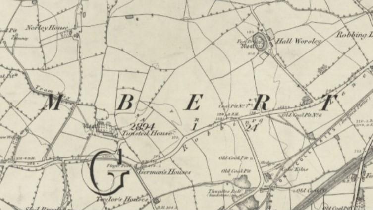
Photo: Peter Walsh
Item #: 34468
Robbings Lane is now Robin Park Road.
Robbing Lane was Ormskirk Road. There was no road in the area of Robin Park Road - just fields leading from what was then called Marsh Green Lane (now Scot Lane) down to the River Douglas. On the map the road between German's Houses and Taylor's Houses is now Tunstall Lane. Thwaites Delf was in the area of the bend on Billinge Road where Trevor Jones' garage was.
True Paul, the area around Newtown was called Robbing Lane Ends and was how the area became to be known to locals as Robin or Robbin, and yes, Marsh Green was once a small country village surrounded by farmland.
Thanks Paul, I see where we are now. Tunstall House would be near St Cuthberts new church and the Old Worsley Hall would be near the playing fields. I see there is a Moat Hall Close on the edge of the estate. Also the Pemberton Collieries Railway went straight through Alexander Park.
According to British History website it was as it says on the map as being Tunstead House on an estate by the name of Tunstead. Maybe with how local folks spoke this was pronounced as Tunstahh and then later became spelled as Tunstall, other interesting local facts are Northleigh or Norley and the Pemberton's being the Lords of the Manor along with the Worsley's of Worsley Mesnes, other place names origins are mentioned with Ellesmere, Winstanley, Worthington and Hindley being the lairds or landowners.
https://www.british-history.ac.uk/vch/lancs/vol4/pp78-83
On figure 3. in this article by Wigan Archaeology Soc. link below, scroll down and the diagram of fig. 3 is just above the title of Douglas Navigation. It looks to be that the colliery railway seen on the 1849 map, and as Peter says looks to be going straight through Alexander park, is the Bankes' railway going to Bankes' pier (what was called Wigan Pier) on the canal on Pottery Road. https://www.wiganarchsoc.co.uk/content/Projects/WiganPier.htm
Cyril, this railway goes straight down past the Saddle to Severn Stars Bridge.