Wigan Album
Three sisters
29 Comments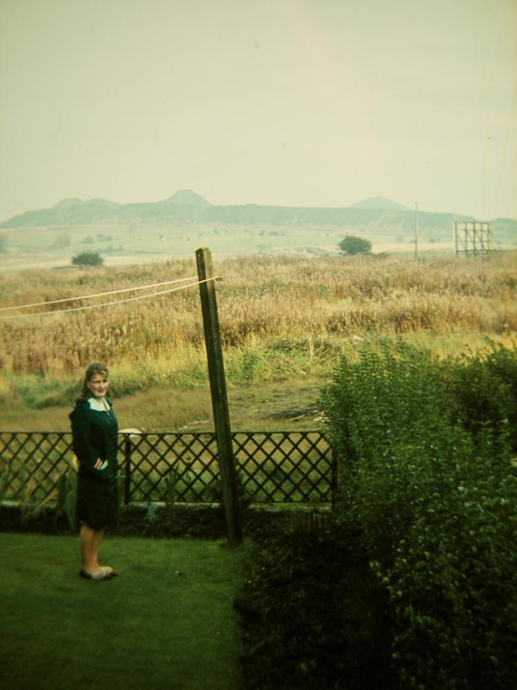
Photo: Roger Whistlecroft
Item #: 24112
Thanks for posting this Roger.
It is very close to the view that I recall from childhood, When we lived on Wigan Road (Top o' Rag Bru) till mid 1960's
Is that an open air cinema screen in the background?
I notice on Google Maps, that the area just to left of these tips, ie in the angle between the railway and the canal, now seems to have a 3 way air strip, and a large private lake, to which there is no public access! As I am no longer local, I would be very grateful if anyone can tell me what that development is.
Hi Roger, as an ex class mate of yours I would say you were around 23 or 24 years old when you took this photo but the photo it's self throws up too many questions, where were you standing when you took it, what is an advertising hording doing in the middle of nowhere and is that the old golf course immediately in front of the colliery tips. Interesting photo though. Cheers Dave
Hi Dave, the land immediately at the rear with the long grass is now Edmund Collins park, before that it was a rubbish tip for ashton. The hoarding was there for many years, hit everyone in the eye as they drove up rag brew, the land before the three sisters was just farmers fields, still the same now I think
That would be good! A drive in cinema at The three Sisters!
I don't recall seeing that screen before, it might have been to do with the golf course, it can't have been an advertising hoarding because it faces away from the road. It could be something to do with the forthcoming redevelopment.
Old golf course lay beyond the long low tip, which extended along edge of the railway cutting. It would be at the extreme RH side of photo, as well: ending about 500 Yards to the right of the rightmost of sisters, as photographed.
What a great photo and a very intriguing one at that. What a fantastic view this would've been from your back garden. I wonder where about's this was taken, I just can't pinpoint it, unless it's from one of the farm houses near by. To me, it looks like it was taken close to Landgate Lane, or could be the area which is now the Three Sisters Road. If so, the background in the photo would now be where the industrial estate is. Or, it could be the land where Viridor Wood is now, looking towards the 3 Sisters and with Lily Lane behind the photographer. I've never heard of this 3 strip airway, although I do know there's a lake that is hidden behind farmland on the opposite side of the Landgate dirt track, so could be there. I've noticed speedboats on it a time or two. Wish there were more photos like this on WW.
I'm told that the stretch of water is a privately owned wind-surfing lake, although it is a bit on the small size. It probably explains why there is a wind-sock near the lake.
'Edmund Collins Park': older folk. will know this as 'the Brick Yard', which is what it used to be before Ashton U.D.C. started to dump refuse there.
AP...the landing strip is used by microlite aircraft, thats all i know.
The water belongs to [url="http://www.youtube.com/watch?v=9lE8sgLWEl4"]Stuart Lillis[/url]. It's a private lake in his back garden. It saves him on petrol instead of keep going to Carr Mill Dam!
when i used play their used to be a bombed out factory
Looks like I am half a mile out!
I see now, it's Wigan Road not Bryn Road.
Now that's what I call a back garden: one that can accommodate a 150 acre water feature.
So this photo must have been taken from a back garden in Dryden Ave ,going down the hill.The Tip is in the background ,this was a ex council dump that was a brilliant adventure playground for us kids. Unfortunately this wouldn`t be allowed these days.
I recall seeing the original proposals for the Three Sisters development. What has been obtained is a mere shadow of what was originally proposed. Does anyone know how the project got so totally salamied?
Ap....correct it was taken from Dryden ave
As this photo was taken years before my time, I asked my dad whether he had heard about a rubbish dump being in the area where the park is now, but he had never heard of it and he has quite a good memory of the area. If this is looking across Edmund Collins Park, then where is the main road and the Landgate housing estate? the suspect the estate must be to the far left out of shot and the road behind the long grass.
Daz: it was Ashton Urban District Council's refuse tip up to the 1950's. I guess it would be circa 1957 when dumping ceased on the site.
Yes, it's correct that a very large rubbish dump was situated where the small park now is. There was a very large advertising bill board there on Wigan Road, Bryn and immediately next to it in a huge hollow was a rubbish dump. The sides were slippery with clay and we used to spend many hours as kids sliding down. There were rats as well and the place was smelly! This was in the midi-1950's.
I was told the lake is 600 yards long and was developed as a water skiing lake after a 10 mph ban was imposed on Windermere.Championships are held and it has been on TV and in Lancashire Life.
I think this photo was taken about 1968/69 because the tips were brought down in late 69,the golden ball pub & landgate estate are to the left of the photo
Dump/ brick yard, along with some maps is discussed elsewhere on this site. Here:
http://wiganworld.co.uk/communicate/mb_message.php?opt=f2&opt2=&msd=891777&offset=280&subject=Rag%20Brew
The old brickyard/tip was leveled in 1972 to make way for Edmund Collins park
Brilliant picture I cannot remember it ever looking like this. I spent most of my childhood in the 1970s playing on Edmund Collins Park and the advertising hording was there then (facing onto Wigan Road). It's true that Wigan Road is hidden behind the long grass. It would be good to take a photograph from the same back garden on Dryden Avenue which is current in order to compare.
As a child, I only had to look at this view, to be completely overwhelmed with the urge to go and climb them! Only managed to climb the rightmost however: still industrial activity about the others, and we used to get chased off.
Hi Roger, do you know which house number in Dryden this was taken at ?
Hi Michelle, it was taken from no 9