Wigan Album
Upholland
9 Comments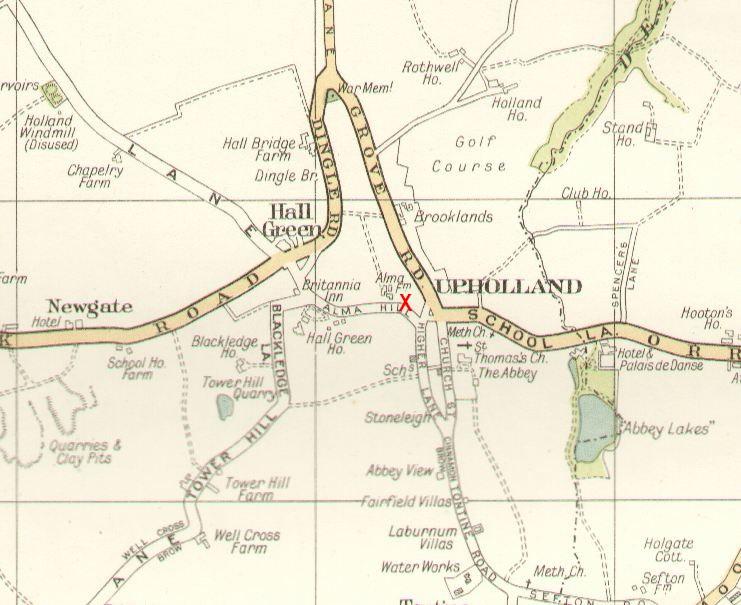
Photo: Mick
Item #: 22640
The location of the Old Dog pub seen in the photo, is marked by the red letter 'X'
Thanks , Mick
I also was confused yesterday, although I knew this area very well in my childhood.
I had forgotten all about about Alma Hill until I googled it yesterday. Will go and refresh my memory of the area next trip back!
Thanks Mick, I know exactly where I am now ! Very good map, shows the footpath, up the steps & over the hill to Hall Green, we would walk back via that path after going to the Lyric Cinema.
The footpath is still there Helen, but it now passes through a small housing estate, rather than over fields.
More memories! Some of my friends and I used to walk from UGS on Sandbrook road to Tontine, then took the marked footpath through Abbey Lakes to catch the bus at the bottom of School Lane.
Mick, do you know of any images of the windmill shown on the map, on Mill Lane--(surprisingly!)? When it was working,I mean. I remember going up there through the fields from Ormskirk Road at Chequer Lane, and seeing a millstone on the ground.
Ellen - I was told the mill was damaged in the Great Storm of 1839, and was never used after that. Sadly this puts it before photography was common, and I have never seen any engravings or illustrations of the mill.
I recall the Abbey Lakes footpath Ellen, I take it you mean the one that went in near the terraced houses on Sefton Road not far from the Majestic? I don't know that it was ever an official footpath but lots of people used it. That footpath was cut off when the Seklemersdale By-Pass (M58) was built in the late 60s.
Ellen, as a matter of interest I once heard that the great storm that destroyed UpHolland Windmill also blew the East Window out of UpHolland Church.
A.W.that's the footpath I meant, I remember that it tended to be somewhat overgrown! It was on one of those times that I first saw swans flying in and landing on the lake;-I was very impressed!