Wigan Album
Platt Bridge
37 Comments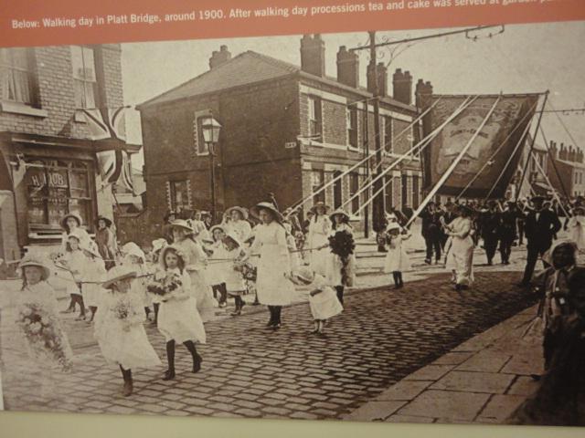
Photo: John Bailey
Item #: 21772
More likely to be Liverpool Road, near top of Neville Street. Don't think tramlines ran that far down Walthew Lane, plus the road seems to carry straight on and not bend left.
Where is/was Elm Street please?
Looks like photo taken in front of the Victoria pub .That would make the street across whistley street but the the street sign appears to have only a short name so John could be right.
Irene, Elm st is/was as the side of right choice kitchens
Thanks Wanner.
Even as early as 1900 there would be 2 annual Walking days, St. Nats & the Methodist Chapels. Which one is this?
I AGREE WITH BERNARD,THE LOCATION IS LIVERPOOL RD.THE SHOP ON THE CORNER WAS A CO-OP WHEN I WENT TO SCHOOL.MY MATE ERNIE BROOKS USED TO BE THE ORDER LAD FOR THEM, TEN BOB A WEEK PLUS TIPS.THE TRAM LINES NEVER RAN PASSED ELM ST.SORRY MAGGIE DONT KNOW WHICH PROCESSION THIS WAS.THE SIDE ST. IN QUESTION IS IN FACT WHISTLEY ST.AND IT LOOKS LIKE THE PHOTO WAS TAKEN FROM THE FRONT OF THE VICTORIA.
I have a problem with this being Elm Street, in that direction the road should bend sharply to the left as it passes where Iceland is now... it does not. I have looked at the photograph zoomed in and the road runs straight.
I would say this is Hart Street on Liverpool Road??
Jonn... the tram tracks DID run past Elm Street.
http://www.ecadfael.fu8.com/os_maps/pb&bl_01.jpg
Dennis,the trams ran down Liverpool Rd.from Hindley turned left into Elesmere Terrace then came out at the cross roads opposite the Miners Hall,there were no tramlines from the T.S.B. TO Lily Lane,which would past Elm St.
John... check the link I posted above. It is a 1908 OS map of the area. It shows tramlines running past Elm Street and then turning into the tramsheds on Tram Street. Okay, it may have just been a service line and not part of the passenger route.
However, I do agree with you that the photograph is Liverpool Road.
JUST AS A MATTER OF INTEREST CLICK ONTO WALKING DAYS ST. NATS ON THE THIRD PAGE THERE HAS BEEN POSTED A PHOTO FROM 1949 OF ST.NATS WALKING,THIS PHOTO IS IN THE SAME LOCATION ASD AS THE ONE I POSTED WHICH SHOWS WITHOUT A SHADOW OF A DOUGHT THAT THEY WERE BOTH TAKEN FROM THE SAME PLACE,FIFTY YEARS APART.THE SHOP ON THE CORNER WAS THE LIVERPOOL RD. BRANCH OF THE CO-OP.
Just a comment, was St Nathaniel's built in 1900? If not was there some church that pre dated it?
Ok Dennis you win on a technicality,regarding Maggies comments the walking day in the 1900 picture must have been the Methodist as St, Nats wasnt built until around 1905.
John, the other other photo you mentioned on walking days doesn't look the same to me. The gable end windows are completely different. I have a gut feeling this could be Moss lane?
Wanner,on close inspection the two pictures are different locations Ime not quite sure where the 1900 photo is but ill find out,not sure about Moss Lane though.
Wanner... I am shaking my head here, in disgust at myself! Of course it is Moss Lane, and I used to live in he 3rd house the terrace in the background, the street we can see is now called Frederica Gardens.
Dennis, thats exactly the location I was thinking. I have been doing a bit of research which definately rules out the Liverpool rd connection. In the 1901 census the shop which is now the derilict launderette was a cloggers owned by a William Nicholson before becoming the Co-op, and the house with the gable end was in fact a Butchers owned by a James Rigby.
Dennis, if you are correct then the photo is taken from, near my house.
Dennis, does your OS map not show a street name for Frederica gardens?
Practically at your front gate Pam. I cannot believe I did not see it, I lived there and missed it!
My recollection is that the street you mention where the new build is was called Frederica St. We lived at 68 Moss Lane and our garden was large. I always understood that there should have been houses there but the owners ran out of money. This is of course prior to the 1950's
Wanner... I had a look, and ended up finding evidence that it is not Moss Lane. Note the lack of tranlines...
http://www.ecadfael.fu8.com/os_maps/1909_ince_moss_05.jpg
.. the photograph clearly shows he overhead power lines.
I agree with Dennis it is not Moss Lane.Trolly buses never ran down Moss Lane,also on the 1905 OS map of Platt Bridge it shows that opposite the shop is a vacant plot devoid of any buildings, it is unlikly that a building was demolished because at that time they would not have been built very long.so we are back where we started,we need senior Platt Bridgers help on this one, Maggie,Frank Liptrot,Gordon Brooks,there must be someone out there who knows the location.
What is that lettering in the window? Looks like " H ?OB " maybe something HOB? HUB? Wash hob? Any such thing? Or maybe the business name of the place? Interesting.. Love the little girls in frilly tunics and black tights. What a picture!
I agree it's not Moss lane. Drove down today on way home from work and the houses have doors to the left and not to the right. Someone must know. I will be seeing my father in law tomorrow he's a life long platt Bridget he might know.
As an old Platt Bridger Im completely at a loss as to where this is. Im sure it must be on Liverpool Rd because that was the tram route. The terraced houses have tiles around the doors and windows this could be a clue!
I've been trying to work out where this is for hours. The houses in the background have no gardens and there seems to be a shop at the end of the row of houses (at least it looks like and awning). I've been looking through old photos of Platt Bridge to see if I could recognise the houses. When I used to be in Walking Days, one day we would walk up Abram and Bamfurlong and the next day towards Hindley. May sound daft but could they have walked towards Springview? its a mystery.
It's just a pity that street sign isn't a little clearer. Also noticed that if you look at the paving flags they appear to be curving slightly to the right. Could it be Walthew lane at the junction of Platt St?
Wanner... go to Albums ->Places ->Platt Bridge. On the very first page the second photograph shows the top of Platt Street from the other direction. Note the shops on *both* sides of Davies Street... the closer one was a butchers in my youth. This is not on the mystery photo.
This is a fascinating thread and I am itching to find out where the photo was taken. I have been through the Hindley Directory for 1925 to see if I can see a shop belonging to "Hobb" or a similar name situated next to a street with a short name but can't find one, but the shop could have changed hands between 1900 when the photo was taken and 1925 when the directory was compiled. Just in case any of you are unaware of it, if you go into "Stuff",then scroll down to "Hindley Directory 1925", the directory also covers Platt Bridge from that time asa well as Hindley, listing all the householders and their jobs, shops etc, street by street. For all you Platt Bridge nostagia buffs, it's fascinating. There is also an Ince Directory from the same year.
Thanks for the info about 'Stuff'. I just found out why the house I used to live in, in Walthew Lane, had a post box. It was a sub post office in 1925.
MY GUT FEELING IS THAT THIS PHOTO IS ELM ST.THE PERSON WHO TOOK THE PICTURE WAS STOOD IN FRONT OF THE OLD ORIGINAL POST OFFICE ON WALTHEW LANE,LOOKING THROUGH THE GAP IN THE BUILDINGS CAN BE SEEN THE GABLE END AND ROOF OF A HOUSE I BELEIVE THIS TO BE SOMEWHERE ACROSS FROM CAR ST.NOWHERE ELSE IN PLATT BRIDGE ARE THERE ANY HOUSES WITH THE FEACTURED BRICKWORK AROUND THE WINDOWS AND DOOR FRAMES,THE ONLY THING THAT PUZZLES ME ARE THE HOUSES AT THE END OF THE PHOTO,THESE COULD BE THE FIRST HOUSES BUILT IN NEW ST ON THE LEFT HAND SIDE,THIS IS 1900 IDONT KNOW IF THE CO-OP WAS BUILT THEN.
I have to agree with John, the location being Elm St. I would guess that right behind the banner the road veers off left (Warrington Rd) and the houses in the distance are New St.If anyone is still unsure go to google maps street view for Elm St Platt Bridge and look at Right choice kitchens shop front and look at the layout of the windows etc and then pan right and you see New St. I think this is pretty conclusive. Have a look and see what you think.
I must say that when I first looked at this photo I automatically thought that it was where my Great Aunt Nellie Bradshaw lived and that is where John and Wanner are saying. In the 60's there must have been a jewellery shop or something like that in one of the houses as I remember buying my mum a broach from there. My Aunty Nellie would have lived fourth or fifth house down.
The/shop/is/called/H??OB/not/hob/theres/a/railing/thing/in
the/way/of/letters......Also/the/street/sign/is/small/does
look/like/it/says/Elm/Street.....Any/chance/of/enlarging/thestreet/sign
The photograph is definitely Walthew Lane/Elm St. The houses in this row had distinctive cream bricks and later strengthening bars.
The road bent sharply to the left at that time. It was changed when they demolished the first houses in Warrington Rd and Kwik Save was built. Nellie Bradshaw did live in this row next door to my aunt.