BOTTLING WOOD DAM
BLIMEY !!!! ad better get mi boat ready !!!! never seen the water this high !!!!
Started: 22nd Jun 2012 at 20:54

completely Unnecessary, there have been flood defences round Wigan since the 19th century
Replied: 22nd Jun 2012 at 20:57
well this water elevation scheme may have solved problems down in the D.W. stadium area (has it ??? ) but what about us on the other side ????
Replied: 22nd Jun 2012 at 21:01
i was speaking to someone last year on Copull mill lane and he said the last time there was a flood there was 30 years ago
Replied: 22nd Jun 2012 at 21:04

If this rain continues the dam may get over topped ![]()
Replied: 22nd Jun 2012 at 21:04

Buzy, it's 'alleviation'. ![]()
But in your case 'elevation' is a better description. ![]()
Replied: 22nd Jun 2012 at 21:05
But whatever you do, don't shout the dog! ![]()
![]()
![]()
![]()
Replied: 22nd Jun 2012 at 21:08
Last edited by dostaf: 22nd Jun 2012 at 21:10:51
They reckoned that the water, at its worst, could reach the level of the roadway on the bridge in the Plantations.
Replied: 22nd Jun 2012 at 21:13
that would be the Roman bridge, someone died in the bywash back in the 80.s so they bricked it up.
not so clever
Replied: 22nd Jun 2012 at 21:17
Last edited by anthony1: 22nd Jun 2012 at 21:17:49
The Environment Agency are aware of, and monitoring the situation regards the dam. If you want any more info, visit their own website at :
http://www.environment-agency.gov.uk/homeandleisure/floods/34681.aspx?area=012WAFUD&page=1&type=Town&term=wigan
This page gives details of the River Douglas with links to the different sections being watched.
Replied: 22nd Jun 2012 at 21:21
Really, Anthony?
I hadn't heard that.
I know the bridge was 'done up' as part of the scheme.
Replied: 22nd Jun 2012 at 21:22
Last edited by dostaf: 22nd Jun 2012 at 21:22:57
Replied: 22nd Jun 2012 at 21:23
Thanks Dostaf!
Twitter link is @envagencynw
Floodline is 08459881188
Replied: 22nd Jun 2012 at 21:28
You're welcome.
Hope those poor beggars who have been flooded are soon sorted.
Replied: 22nd Jun 2012 at 21:30
There are 62 flood warnings alone in our district. The Lune is looking quite full with fresh water coming down from the hills, but there is a tide at 2 in the morning 8.9 m I reckon there is more than 8.9 meters now. Wonder how Gathurst is going on with the River Douglas.
Replied: 22nd Jun 2012 at 21:39
DOSTAF .... I FORGOT ONE L WHAT A CRIME !! GET A LIFE
Replied: 22nd Jun 2012 at 21:41
well with respect... some chap was down there in Bottling Wood to monitor what was going on. at the moment we cant get into the plantations from bottling wood .... i have never known this to happen in my lifetime .... SORRY DOSTAF IF I HAVE SPELT ANYTHING WRONG !!!!
Replied: 22nd Jun 2012 at 21:57

It is quite bad down at the dam today. Click here to watch a video of it.
Replied: 22nd Jun 2012 at 23:11
I'm on patrol down there in the morning so I'll report back. and give an update.
Replied: 22nd Jun 2012 at 23:44
Thanks for the video arrow.... it actually got a lot worse because when i went down the steel poles were totally covered.
Replied: 23rd Jun 2012 at 07:25

So really if the area near the river around Eleanor St and the old bus depot have not flooded,the dam has worked!
Replied: 23rd Jun 2012 at 07:40
It never flooded much before, so it can't be said that the damm worked
Replied: 23rd Jun 2012 at 07:50
I don't suppose you have ever been affected by flooding from a river or stream Anthony,but I have,and I can tell you it only has to happen ONCE to have a devastating effect on a family!
I think that Eleanor St may have flooded a few times or were considered at risk!
" 4.1 Who is at risk of flooding?"
• There are two main flood warning areas in the borough they are:
- River Douglas - Eleanor Street, Wigan
- Lilford/Bedford area, Leigh
The Wigan flood warning area extends from Central Park Way and includes
properties in Scholes and Robin Park. Properties affected are both commercial
and residential and include Asda, the bus depot, Scholes Weir and properties
surrounding Adams Bridge. Tesco’s, on the site of the former rugby ground, is
also a flood warning area, but as it is built on higher ground, the risk from flooding
has been reduced."
Somebody thought so from the council and that is why they built the dam!
Replied: 23rd Jun 2012 at 08:08
Last edited by fossil : 23rd Jun 2012 at 08:09:57
If the area around Elanor St. didn't flood last night then obviously the dam is working... but what about the people down the Leyland Mill area ? have they been affected ???
Replied: 23rd Jun 2012 at 08:37
Last edited by buzybee: 23rd Jun 2012 at 08:49:26
Anthony said:
” It never flooded much before, so it can't be said that the damm worked”
So it didn’t flood there much did it, well in the great flood of the latter part of the year 2000, I think it was in November, the River Douglas flooded under the railway bridge on Wallgate and the police closed the road. At about the same time Scot Lane flooded at Martland Mill in between Martland Mill Lane and the road bridge across the River Douglas, thus closing the road there and I remember wading waist deep in water, carrying a pram over my head, so that the lady and her baby who were going to Marsh Green, could get home, me a Wigan taxi driver responding to a crisis and going beyond the call of duty to ensure I got me ‘fare’ to their destination, like the old saying says, “when the going gets tough the tough get going” and it was worse on the way back to the cab, because the water had got deeper and I had to swim back along Scot Lane under the railway bridge and there was tree branches, rats, shit and all sorts in that water and when I got to the other end I was pulling bits of twigs from between me teeth ![]()
Then I realised that there are only three ways across the River Dougie, in Wigan,,, Scot Lane near Beech Hill, Wallgate near Asda and Chapel Lane near Poolstock and on that particular day, Chapel Lane was the only way to get across the Dougie, if you were travelling to the South of Wigan Town Centre,, so on that particular day I gave up trying to get home by going via Chapel Lane after sitting (soaking wet) in a traffic jam on Woodhouse Lane, for three hours, because the traffic was so bad and I ended up going home via Southport, it took me seven hours to get home, to Woprsley Mesnes,, so Anthony if you don’t mind, I think your views on flooding in Wigan are a not exactly reet ![]()
Replied: 23rd Jun 2012 at 08:58
"If the area around Elanor St. didn't flood last night then obviously the dam is working... but what about the people down the Leyland Mill area ? have they been affected ???"
I don't know Busybee,you brought it up and as it seems like you have been down to look for yourself,you tell us!
Replied: 23rd Jun 2012 at 09:05
Imagine if those posh houses on the site of Brock Mill, end up getting flooded out, because some bright spark decided to 'dam; the River Douglas at bit further down the Douglas Valley ...
Replied: 23rd Jun 2012 at 09:09
hi fossil.. i have only been down the Bottling Wood area so i don't know .. the scheme was intended to stop the flooding in the Robin Park area... so like i say... if they didn't get flooded the scheme has worked... but the back up of water on the other side may have affected the the Brock Mill area . Was hoping someone from that side would let us know. ![]()
Replied: 23rd Jun 2012 at 09:18

Just seen coverage on SKY news of Wigan and Yorshire, I really feel for those whose property is damaged, hope everyone is ok.![]()
Replied: 23rd Jun 2012 at 09:31
me to v.g.
Replied: 23rd Jun 2012 at 09:45
I know there are low-lying areas that have always been at risk of flooding, and we have seen a months rainfall in 24 hours or whatever it is, but listening further to these news stories, the problem of 'blocked drains' keeps cropping up - surely local authorities/water companies should be routinely checking the drains?![]()
Replied: 23rd Jun 2012 at 10:11
Busybee,
I would think that the water levels involved in the storage of water at the dam would be such that levels higher up the water course ie Brock Mill area would not be dangerous!
The dam is designed to cope and store with a controlled release.
" In the event of a major flood, water would be held behind the dam to reduce the chance of flood defences in Wigan being overtopped. The excess water would then be stored in the valley upstream from the dam. After a flood, the stored water would be slowly released back into the river until normal river levels are achieved."
That is the aim, and well done if it has worked!
It really looks that the authorities need to sort the situation out in Springfield,it is terrible what those poor people have to put up with![]()
Replied: 23rd Jun 2012 at 11:03
well from what i have heard .. the Asda area was a nightmare... like you say fossil the authorities need to have a look at the situation ![]()
Replied: 23rd Jun 2012 at 13:11
SORRY IF YOU DIDN'T SEE MY POINT, BUZYBEE.
Replied: 23rd Jun 2012 at 13:55
Lets hope that alleviates the situation![]()
Replied: 23rd Jun 2012 at 14:05
A great malaprop. Especially fitting with respect to the concern of elevated water levels upstream.
Some bonny houses here now.
Replied: 23rd Jun 2012 at 14:15
Last edited by dostaf: 23rd Jun 2012 at 14:49:26

Here dostaf, i'll lend you one of these to fix your link with. ![]()
Replied: 23rd Jun 2012 at 14:45
Last edited by the borg: 23rd Jun 2012 at 14:51:14
Ooops ![]() . Ta, Borg. I'll stick it in, like that little Dutch lad and the dyke.
. Ta, Borg. I'll stick it in, like that little Dutch lad and the dyke.
Replied: 23rd Jun 2012 at 14:47
DVD available soon. ![]()
Saw one daft sod in Yorkshire, on the news, telling how his car got stuck.
"It was ok to drive through at first as the water was only two to theree feet deep"
Replied: 23rd Jun 2012 at 14:52
He said he didn't think it was very deep,because it only came halfway up yon duck.
Replied: 23rd Jun 2012 at 14:56
![]()
![]()
![]()
Mytholmroyd, Hebden Bridge and Todmorden.
The word 'royd' in Tyke place names means clearing near a river, not their disposition.
Or something like that. (Bowt googlin)
Replied: 23rd Jun 2012 at 15:01
Sorry, Anthony. Only just caught your 'hypothermia' reply.
Thanks.
Replied: 23rd Jun 2012 at 15:04
Yes ![]()
But no hydro brakes.
June explanantion:
The two cone-shaped Hydro-Brake® Flow Controls are 2 metres in diameter, weigh 15 tonnes each and were lowered into the dam with a 200-tonne crane.
Replied: 23rd Jun 2012 at 15:12
Last edited by dostaf: 23rd Jun 2012 at 15:13:20
Fossil
I'm not say being flooded is good or bad.
I just stated a fact, I come from Poolstock and spend a lot of time round the red pond and the dougie, the damm makes not one iota of difference.
only to cause flooding there
Replied: 23rd Jun 2012 at 15:13
Last edited by anthony1: 23rd Jun 2012 at 15:17:57
"I'm not say being flooded is good or bad."![]()
Most of the time I am not with your conspiracy theories and in this case I have seen the news and witnessed the extensive flooding all over the area,and I believe that huge expanse of water up whelley might have been making it's way normally down Eleanor St yesterday!!
And just because you live in Poolstock , doesn't make either of us drainage experts,but I do know flooding is BAD!!!
Replied: 23rd Jun 2012 at 15:35
all the water that used to soak into the ground lands on concrete and from there into the drains and from there into the rivers.
this is from everywhere that has drains, they all empty into the rivers.
Most of the time I am not with your conspiracy theories
you just can't be reasonable with some people, you immature tosser
Replied: 23rd Jun 2012 at 15:49
Stick to bullying women ant![]()
![]()
Replied: 23rd Jun 2012 at 15:52
I don't bully anyone, debate the flood by all means, but don't make personal attacks. tosser
Replied: 23rd Jun 2012 at 15:56
Last edited by anthony1: 23rd Jun 2012 at 15:58:58
Where did I make the personal attack ant![]()
Replied: 23rd Jun 2012 at 16:00
it's there in red pal
Replied: 23rd Jun 2012 at 16:01
Last edited by anthony1: 28th Jun 2012 at 18:24:44
So not agreeing with you is a personal attack![]()
![]()
![]()
You are sadder than I thought you were!
Replied: 23rd Jun 2012 at 16:05
Grow up![]()
Replied: 23rd Jun 2012 at 16:16
so we've heard from stoo about the great flood of 2000,
when did these floods start at asda and surroundings? anyone?
maybe stooo knows
Replied: 23rd Jun 2012 at 16:16
Last edited by anthony1: 23rd Jun 2012 at 17:02:50
Historically the Dougie has always flooded at Newtown, because that area is probably the lowest part of Wigan.
Before the dam was built in Whelley, there was work done on the River Douglas, about five years ago the banks were raised along the of the Douglas from Poolstock to Martland Mill and 'that' along with the dam at Whelley stopped the Douglas flooding at Newtown yesterday, the flood at Asda was caused by the sheer volume of rain falling there and the drains not being able to cope and if the Dougie had flooded, Wallgate going under the railway bridge, would have been under about three feet of water and would have been shut to traffic, so the 'flood defences worked in Wigan yesterday and you thank the Environment Agency for carrying out all the work on the River Douglas, over the last few years ![]()
Replied: 23rd Jun 2012 at 17:02
prior to the stadium and the precinct at Robin park, I can't recall a time when asda was flooded. in fact the floods started when the stadium was built
It was flooded yesterday
Replied: 23rd Jun 2012 at 17:10
Last edited by anthony1: 23rd Jun 2012 at 17:11:22
Anthony
Where Asda is now, is where years ago there was a builders merchants on Soho Street and that used to flood and if you remember the road which ran at the side of Asda where the rifle club was located, there was a dip in the road and that always used to flood there, I remember going canooing there once and the shop floor at Asda was built to be above the level of the Dougie and that is why the present and former Asda stores have never flooded and during the 1970's 80's and 90's there was never a cataclysmic flood at Newtown, because there was never during those times a weather event to cause it and some work was done in the early 1970's to 'alleviate' the flooding risk at Newtown, underground flood tanks were installed near to where the stadium is now and the Dougie was widened at Martland Mill to create a floodplain ![]()
Replied: 23rd Jun 2012 at 17:22
Stoo you are a fountain of information.![]()
Replied: 23rd Jun 2012 at 17:32
alot of what you say is correct, my contention is that the floods at Newtown aren't caused by water from whelley but by lack of natural drainage brought about by the stadium, the robin park development and more recent works.
of course the dip in the road on soho street filled and we have had a couple of unusual weather events, but the volume of water now entering the river via the drains is far greater than it ever was.
Take a look at a pre damm pic of the bottom of Coppull mill lane.
it was a large valley enough to accommodate any flooding, people there say they never had any flooding for 30 years.
not that they ever did as the houses are 25 feet above the water level
will get back to this later.
going to watch Joe Longthorne at the Monaco
Replied: 23rd Jun 2012 at 18:14
Last edited by anthony1: 23rd Jun 2012 at 18:16:25
anthonthy1 .... the original Bottling Wood was alongside the Douglas .. take a look at pictures over the last 100 years .. there was a corn mill down there and a pub ..
Replied: 23rd Jun 2012 at 18:43
Ant ,
Make sure the air raid blinds are shut when you go out![]()
Enjoy!
Replied: 23rd Jun 2012 at 20:05
Last edited by fossil : 23rd Jun 2012 at 20:11:10

I live in Newtown and I am bloody sure if the dam had not been built quite a lot of Newtown and possibly Asda would have been under quite a lot of water![]()
Replied: 23rd Jun 2012 at 21:39

Dam or no dam, Newtown will always flood because it's the lowest place and water always flows downhill.
They'll have to build a huge pumping station there and pump the water away.
Replied: 23rd Jun 2012 at 23:26

there's a nice little weir in Scholes that regulates water flow of the Duggie.............today our stretch of the river was no more than 3 inches from overflowing so it has to go somewhere........get the dredgers out and get rid of all those Asda trolleys.....
Replied: 23rd Jun 2012 at 23:31
so why were we not submerged before the damm
Replied: 24th Jun 2012 at 00:18
cos the water was regulated from the dam and through the weir. The flooding was excess rain and inadequate sewers not the river.
Replied: 24th Jun 2012 at 00:20
exactly, as I said in my last but one post, asda was flooded yesterday inspite of the damm.
so obviously the damm made no difference
Replied: 24th Jun 2012 at 00:25
Last edited by anthony1: 24th Jun 2012 at 00:45:13
Asda was not flooded, the small roundabout near Burgerking was. If the dam had not been built the store would have been flooded. The reason being was purely the amount of rain that was put down, if only some people would watch the weather forecast![]()
Replied: 24th Jun 2012 at 00:52
gemfree
Here's that nice little weir you are on about ![]()
http://www.youtube.com/watch?v=fgWqdKWxErY
If you notice the river was running a brown colour that day and it had been raining hard, but that brown colour was not 'sediment' it was sh*t ![]()
It absolutely stunk and obviously raw sewerage had got into the river from somewhere ![]()
Replied: 24th Jun 2012 at 08:11
rio
that's when it always floods, when we have voluminous amounts of rain.
That's the only time it flooded before the damm,
now we have two areas flooded instead of one.
Replied: 24th Jun 2012 at 09:52
who would have thought that in times of prolonged and heavy rainfall that rivers would overflow onto their natural floodplain, the majority of sewers in Wigan are combined flows ie foul and surface water and so when the surface water flow increases they are designed to overflow into the river and stream system at I think 6 times normal flow rate thus diluted sewage will be in the floodwater, no sewer system in the country will take all of the combined flows in times of storm, sections of the system have retention storage but if this is full and the storm carries on as Friday you will get flooding end of
Replied: 24th Jun 2012 at 13:38

Hear hear, build on flood plains, then complain when you are flooded.
Replied: 24th Jun 2012 at 15:25
The lower plantations are going to be decimated if the dam keeps causing floods there.
I was there last night and this is what I saw.
After the Flood
Replied: 24th Jun 2012 at 19:12
I'm sure if Wigan lane starts getting flooded they will open the dam and pass the flood down to Newtown.
Replied: 24th Jun 2012 at 19:17

This one is on you tube, put on by Arrow501
The Dam at work
Replied: 24th Jun 2012 at 19:23
well never mind its only another 12 million down the drain![]()
![]()
![]()
![]() no one cares apart from folk in beresford street.
no one cares apart from folk in beresford street.
Replied: 24th Jun 2012 at 19:24
Baker Boy
What do you mean another 12 million down the drain, the dam 'worked' and the flood at Beresford Street had nothing what so ever to do with the River Douglas or the 'dam' ...
Replied: 24th Jun 2012 at 20:53
the dam worked, how so?
we still have the same floods, pre and post dam
Replied: 24th Jun 2012 at 22:45
The dam creates a flood backwater of the Douglas when its switched on, and the lower plantations will be become stripped of many ancient trees.
Replied: 24th Jun 2012 at 22:51
I agree there Bennie,but that is what happens to rivers in flood,the trees on the banks are casualties.
I have fished on the River Eden and Severn when they are in flood and have seen trees,3 piece suites ,and even cows and sheep float past!
Replied: 24th Jun 2012 at 23:01
I would never dream of making a personal attack on someone on WW but all I can say is I am glad I was not the person in charge of anthony 1's education because that truly was a waste of public money![]()
Although several older trees may be lost, surely it is better than people losing their homes and livelihoods?
Replied: 24th Jun 2012 at 23:03
first the Flashes, now the Plantations.
rio
stop talking b*llocks
Replied: 24th Jun 2012 at 23:04
Last edited by anthony1: 24th Jun 2012 at 23:06:42
stoo
was it not a flood at beresford st from the douglas not being able to take all the water.i have a good idea, why dont we spend another 12 million widening and deepening the douggie
Replied: 24th Jun 2012 at 23:09
Good God, another waste of public funds![]()
Replied: 24th Jun 2012 at 23:23
make as many personal attacks as you like,
they are just more evidence of a lack of argument,.
I'll concentrate on the topic
Replied: 24th Jun 2012 at 23:34
baker boy
the flood in beresford street is a combination of poor drains and ,probably more significant, Barleybroook that runs underground around there.
Thats why they are feeding it into the canal as I filmed HERE
Replied: 24th Jun 2012 at 23:35
i cant speak for the dam or the river up at the plantations, but at the saddle end then the dam has worked.
Replied: 24th Jun 2012 at 23:51
how so? we still get the same floods as we did before the dam was built.
Replied: 24th Jun 2012 at 23:57
the river down at the saddle end has burst its banks on many occasions. this time it did not.
Replied: 24th Jun 2012 at 23:59
redtop, you're wasting your time. You can't put owt where there is nowt![]()
Replied: 25th Jun 2012 at 00:48
The big tree that had uprooted was probably weakened in the first place by the construction of the footbridge.![]()
The other one (nearby) isn't likely to last much longer either.
PS good filum Bennie![]()
Replied: 25th Jun 2012 at 01:31
I think it will be down to the Environment Agency to clean up the mess after the man made flooding the Douglas Valley, because if they don't the water flow through the dam may get blocked, with the debris and I think that is what they will doo, but I think folk maybe shocked at the amount of trees the Environment Agency will chop down in the Douglas Valley ...
Replied: 25th Jun 2012 at 07:41
the river down at the saddle end has burst its banks on many occasions. this time it did not.
redtop
have you noticed anything different about the river at the saddle end?
yes they've built flood defences.
there's people on here trying to make the claim that we had delude after deluge and then they built the dam and hey presto sorted
well
I live close to this area and have done for the greater part of my life.
I walk my dog every round red pond including the area near eleanor street,every day rain or shine and have done for donkeys.
I visit asda every day and have done for many many years
don't try to push this rubbish down my throat.
it won't wash ![]()
redtop, you're wasting your time. You can't put owt where there is nowt
nothing intelligent to add
rio
everyone else is talking about the Dam
Replied: 25th Jun 2012 at 08:24
Last edited by anthony1: 25th Jun 2012 at 08:53:00
we will have to agree to disagree, i too have lived down near the saddle all of my life.
i have seen it flooded on many occasions down were the figure eight meets the river. that was one of the worst spells of rain on record for a 24 hour period.
whether it was down to the dam then probably only the environment agency know for sure.
Replied: 25th Jun 2012 at 08:53
It got worse when they built the stadium and the robin park complex.
january 2012 flood wep
Before, this was because we didn't have a dam.
now we have a dam and the same thing happens it's a different kind of flood.
heard anything like this before?
'leaves on the line'
'wrong kind of snow'
Replied: 25th Jun 2012 at 09:16
Last edited by anthony1: 25th Jun 2012 at 09:38:35

Anthony,,, what you are saying just does not 'wash' at all ![]()
![]()
Replied: 25th Jun 2012 at 09:36
it must be a pain for him having to keep track of who he is at any given moment.
anyway sir bob
give us your view of the floods
Replied: 25th Jun 2012 at 09:40
Last edited by anthony1: 25th Jun 2012 at 09:43:08
Hello Mac ![]()
Replied: 25th Jun 2012 at 09:42
I agree, Ant. He's slipped up a few times already.
Replied: 25th Jun 2012 at 09:43
Doo yoo really think that I have slipped up Mac ![]()
Replied: 25th Jun 2012 at 09:45
Actually Anthony the water we have here in Leigh is much 'softer' than the water you have in Wigan ![]()
Replied: 25th Jun 2012 at 09:48
Anthony
The oo's are a speech impedement I was born with and it spills over into me writing/typing as well ![]()
Replied: 25th Jun 2012 at 09:53
water's come a long way since the days of 'soft' and 'hard'
now we have smart water that does whatever the council wants it to
Replied: 25th Jun 2012 at 09:53
Leigh water makes nicer cups of tea and coffee, that is why all the cafes in Leigh are always busy ![]()
Replied: 25th Jun 2012 at 10:24
Hi Veg Grower
I used to go and have a mug of tea and a bacon butty in Frank's Cafe in Tyldesley and once I bought a sailing dinghy from Frank ![]()
Replied: 25th Jun 2012 at 12:47
Was it over 30 years ago that you bought it? Only reason I ask is that someone else has owned the cafe for the last 30. I've never sat down to have anything to eat in there, fish and chips are nice though to take out.![]()
Replied: 25th Jun 2012 at 13:39
Apls/stoo-pid/sir boob, all one and the same.
Replied: 25th Jun 2012 at 14:18
Ah yes.![]()
I wonder who holds the record for the most aliases? Past, present and current, I guess we will never know.![]()
edit: Past, present and current???![]()
Replied: 25th Jun 2012 at 14:23
Last edited by veg grower: 25th Jun 2012 at 14:27:18
Ey up ...........
No wonder me ears have been burning,, with all this talk about me and who the hell is that Sir Bob ![]()
Replied: 25th Jun 2012 at 14:43
So far Stooo - you hold the record for most aliases - not that others are likely to come forward mind.![]()
Replied: 25th Jun 2012 at 14:47
Sir Bob is an imposter, a pretender to my throne ....

Replied: 25th Jun 2012 at 14:55
Did beresford street used to flood before the stadium was built?
Replied: 25th Jun 2012 at 17:10
Apologies to you Dostaf .... just read all through the thread again.... i get your drift now !! ![]()
![]()
Replied: 25th Jun 2012 at 18:33
No worries Buzy. ![]()
As I typed, a lovely and fitting mix.
Replied: 25th Jun 2012 at 18:35
Cheers D ![]()
Replied: 25th Jun 2012 at 18:36
not in my recollection, but if it did i'll bet they used it as an excuse to build the dam.
Replied: 25th Jun 2012 at 18:42
Wonder why it is called "MIRY" Lane![]()
![]()
Replied: 25th Jun 2012 at 19:16
maybe a woman called Mary or Moira lived at the end of the lane
Replied: 25th Jun 2012 at 19:40

The damn at the bottom of coppull lane was there to stop the area round asda and dw stadium. Well after looking at the pictures of the area round asda it is clear to say what a waste of £12 million.
Replied: 25th Jun 2012 at 22:50
Damn and blast it, Gareth! ![]()
Replied: 25th Jun 2012 at 23:09
As regards 'Miry Lane' - perhaps there was persistant flooding in years gone by and the Lane was always a 'mire'.![]()
![]()
Replied: 25th Jun 2012 at 23:15
Veg Grower
I would agree with that assumption, because the land around Miry Lane is very boggy ![]()
Replied: 26th Jun 2012 at 07:27
could have been just an unadopted or unsurfaced road in days gone by.
I've only seen Miry lane flooded once in my lifetime, that was with water they used to put Taylors fire out in the 60's
Replied: 26th Jun 2012 at 10:51
Last edited by anthony1: 26th Jun 2012 at 10:52:35
Once again, the ill-informed, attention-seeking councillor steps in and posts an innaccurate,garbled and frankly outrageous statement. Stick to your own Ward, councillor, and try to research a topic before you make such ridiculous comments.
ps, get a spell-checker on your laptop!!
Replied: 26th Jun 2012 at 11:53
the problem around asda was poor drainage.
Replied: 26th Jun 2012 at 13:53
from what i can see, the dam worked a treat.![]()
Replied: 26th Jun 2012 at 16:09
asda was flooded again and so was the railway bridge near seven stars,so what did the dam thing do exactly.stopped it flooding worse.perhaps my jokey idea of widening and deepening the douglas isnt such a joke.where does the dam stop it flooding?
Replied: 26th Jun 2012 at 17:33
best go to specsavers ![]()
Replied: 26th Jun 2012 at 17:34
every time it rains, there is water lodging near the bridge on the side where traffic is coming away from wigan town center,but it aint anything to do with the dam or the river bursting its banks.
Replied: 26th Jun 2012 at 17:38
Exactly redtop it's the drains,the river is sorted![]()
Replied: 26th Jun 2012 at 19:33
anthony 1, I work at the Pagefeild Works and the entrance is on Miry Lane just at the bottom of Beresford St and in the last five years it has flooded on at least six occasions.
All I can say regarding the councilors comments is "Who in their right mind would vote for him?" Talk about not engaging brain before opening mouth
Replied: 26th Jun 2012 at 19:55
whatever the flooding situation at all the locations the fact is that the dam held back water that would have ended up somewhere downstream whether it was worth it or not who knows
Replied: 26th Jun 2012 at 19:56
tonker...lol![]()
Replied: 26th Jun 2012 at 22:33
....and once again, all the councillor can do is ignore the genuine and accurate comments. Are all politicians so self-serving and ignorant?
Replied: 27th Jun 2012 at 10:01
Take a look a 'PHOTO OF THE DAY' imagine what it would have been like if the water hadn't been held back ![]()
Replied: 28th Jun 2012 at 07:40
Buzybee
it got like that before they built the dam.
haven't you read my earlier posts?
the situation before and after the dam hasn't changed one bit, it is exactly the same.
Was the dam a waste of money?
Not for some.
Rio
Doesn't it feel good to make a good point without resorting to common insults.
But I do have to point out that Miry lane didn't always go as far as Beredsfords street, in the 60's and 70's the area beyond Prescott st was known as Firelli's tip there was a dirt track with a caravan site at the end.
Before that I don't know, maybe someone on here may have an old map.
Quote of the week from Elmos
"from what i can see, the dam worked a treat."

Replied: 28th Jun 2012 at 08:40
Last edited by anthony1: 28th Jun 2012 at 08:57:11
Av told Elmos he should go to specsavers !! ![]()
Anthony 1.... point taken... i know it has always had a problem down that area... but i don't live that way so i have never really known if things have changed or not. Obviously not. ![]()
Replied: 28th Jun 2012 at 10:28
Because the drains can't cope has nothing to do
with the dam,av been told it sometimes floods in
bottling wood!! never heard t![]() he duggie being blamed
he duggie being blamed
for that.
Replied: 28th Jun 2012 at 10:50
Replied: 28th Jun 2012 at 11:28
elmos said, "Because the drains can't cope has nothing to do
with the dam ...."
Of course it hasn't. But it does prove that the dam hasn't stopped the flooding.
Replied: 28th Jun 2012 at 13:23
Anthony.
Gaffer's map.
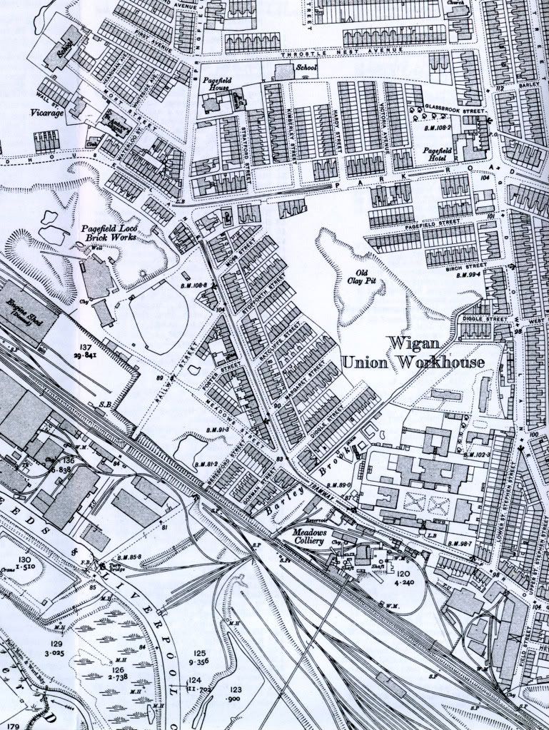
From here
Replied: 28th Jun 2012 at 13:53
You're welcome.
I think the map may be the 1908 one.
Replied: 28th Jun 2012 at 15:05
Here is a map of the area from 1969 which would appear to back up what Anthony says about where Miry Lane ran to in those days ![]()

Replied: 28th Jun 2012 at 15:18
Thanks Stooo
I think the oblong thing is the caravan site
Replied: 28th Jun 2012 at 21:05

Just one question where did the River Douglas burst its banks ?
Replied: 28th Jun 2012 at 21:21
We all have our opinions, as far as I am concerned and knowing what had happened previously I am still convinced that the building of the Dam prevented a lot of damage around the Newtown area. And believe this or believe it not I was dead set against the building of the Dam from the outset![]()
Replied: 28th Jun 2012 at 23:00
I will repeat that has well as the dam being constructed, the level of the river bank in the Newtown area has been raised considerably during the last few years, to help alleviate the flooding problems caused there and the when Wallgate used to flood under the Seven Tars railway bridge, it was caused by the water coming up through the drains, because the drains carried rainwater away from Wallgate and emptied it into the River Douglas, so when the river was 'in flood' and the river reached a certain level, the drains would reverse flow and the water would come up through the grids and flood into Wallgate and that would be the case until the river level went down to below the level of Wallgate under the railway bridge ...
Replied: 29th Jun 2012 at 07:22
Last edited by stooo: 29th Jun 2012 at 07:32:46
Are you refering to the new wall near where the bus station used to be?
I was speaking to some of the residents of Eleanor street just when the wall was finished.
They contended that the wall is part of the road that is going through there, they just swapped one wall for another.
It isn't any higher just the railings on top
it's cosmetic
Replied: 29th Jun 2012 at 09:11
Last edited by anthony1: 29th Jun 2012 at 12:20:30
A look back at this thread just exposes the amount of good this scheme did to alleviate flooding in the Eleanor St area.I just wonder what Anthony’s thoughts would be 7 years on.
My own opinion is that the people who designed the scheme deserve commending for it.
Replied: 16th Nov 2019 at 12:35
The scheme close to eleanor st has worked,
But then they have redeveloped the place,
But that isn't the dam asda and the bridge are still flooding to the same extent
Replied: 16th Nov 2019 at 17:45
I would have thought that the Asda area problems are caused by a very poor surface water drainage problem,unconnected to the flood alleviation scheme.
Replied: 16th Nov 2019 at 20:05
The Asda area problems are caused by the fact that it's the lowest area on the course of the river. The ground there is lower than it is further downstream. It needs the bed of the river clearing to increase water flow.
Replied: 16th Nov 2019 at 20:48
hey raised the banks instead .
Replied: 16th Nov 2019 at 21:44
That's how stupid they are!
Replied: 16th Nov 2019 at 22:39