Wigan Album
Victoria Colliery
13 Comments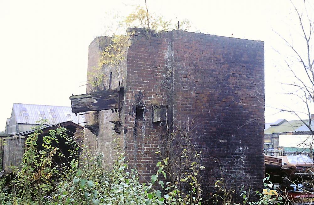
Photo: Bill Aldridge
Item #: 32541
These old colliery photos are brilliant, where was the Victoria pit, I should know but can't bring it to mind !
Between Chorley Rd and Wigan Rd, behind the Boar's Head Filling Station.
Victoria colliery was just off Lurdin Lane.
The shaft isn't in the picture though.
John Walsh is correct. That isn't one of the shafts. It is just what is left of one of the surface structures.
That's interesting Chris - just assumed it was, seem to remember it being in the right location. What else could it have been?
Looking at old maps, and the orientation of the photo, which I assume is taken from the railway side, I reckon that the structure shown is the corner of the pit bank surrounding the North shaft. Depending on how far this structure is from the main winding engine house, the shaft may possibly be hidden under those stacked up scrap cars to the right, capped off of course.
Most admit it's a bit confusing but I don't think it was on the north side of the engine house as other photos show different structures on that side https://www.wiganworld.co.uk/album/photo.php?opt=5&id=23189&gallery=Victoria+Colliery&page=1
The maps show large structures on either side of the engine house with the shafts located in the middle of them. other photos show these structures as sheds https://www.wiganworld.co.uk/album/photo.php?opt=3&id=28107&gallery=mining&offset=220
(unfortunately it doesn't help us to identify our building though)
The structures at either end of the winding house are the pit banks or sometimes known as heapsteads. They were elevated structures, steel frames, large brick sections in some parts with corrugated roof coverings. they were elevated so that when the tubs of coal came up they would gravitate away from the shaft cages to the coal cleaning plant. There would be a tub track circuit within the structures to provide an in and out into the cage. At Victoria the coal screening sheds were to the south of the south pit. I presumed that the photo above was on the north side of the winding house because someone on one of the other photos mentioned it and that I then presumed that the railway would be behind the photographer.
There wouldn't have been a brick structure around either of the shafts at Victoria because it was fan ventilated not furnace.
Also, the shafts were 20ft internal diameter so they wouldn't fit inside the brick structure in the photo.
Did you take the photo? If you did, can you fix the structure's position in relation to the engine house?
Chris; both shafts were at the side of the railway, the south shaft is now in lordy close near water drive,the north shaft is near the footpath north of lordy close the brick structure I think is part of the pit bank which surrounded the shaft.my guess its the south shaft ?
AH, it is definitely not one of the shafts, I agree. It is hard to tell exactly what it is apart from part of either of the pit bank structures. As regards the shafts, I think you are mistaken about the position of the south shaft. The south shaft is right at the north end of the garden of No 16 Lordy Close. An allowance for slight error In my plotting may put it just outside the garden in the trees area which seems more feasible as I don't think it would have been allowed to have been included in the property of a private dwelling in case anything went wrong.
There are two more shafts in the vicinity. Both are very old shafts, early 1800's long before Victoria was sunk. One is shown on old maps about midway between the North and South shafts just to the west of the winding house. The Coal Authority have no record of this.
The other one plots beneath No 2 Lordy Close according to the Coal Authority.
I am going to post a Google image on here shortly to show the shaft positions. It may take a while as it is ages since I posted images on Wigan World. It seemed complicated last time. I hope it is easier now. I am more used to posting on facebook which is a lot simpler and quicker.
Chris,as i said the south shaft is in lordy close possibly in someones back garden at the footpath end of the close; follow the footpath out of the close ,the north shaft is in the trees on the right hand side
Chris, unfortunately I can't remember where I took the photo from, it's such a while a go now (looks like there was a scrap yard next to it and some old buildings in the distance on the right - maybe they were some of the old colliery buildings still standing at the time).