Photo-a-Day (Wednesday, 28th November, 2012)
Orrell and Billinge Hill from Standish
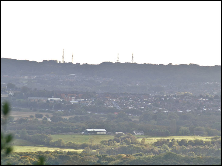
Photo: Rev David Long (Konica Minolta Dynax 7D)
Good description,Rev. I looked at your photo through a magnifying glass and spotted everything you mentioned. I spent the first 33 years of my life in the mddle of that picture, before emigrating to Canada.
Alan
p.s. If you ever pass Orrell Gardens with your camera....do me a favour !
I would guess at the cream house being at the junction of Lathom lane and Springs road and the farm building being on Achurst lane.
Where do I start!! Rev David, what a history trip for me. I was born in Billinge hospital on the 16th of August 1949, so that is the Billinge connection. I lived just outside Standish at 181 Pepper Lane and went to St Marie's RC primary school when it was on Almond Brook Road. Then when the new St Peter's was built I attended until I was 14 then we flew to Australia. Thankyou Rev David you have made my day!!!! Cheers!!
Rev David, this is a nice change by
looking in opposite direction to Winter Hill !!
Had to put photo in Windows Photo Gallery and magnify in order to see the parts you specify.
Have had a quick look on Google Earth and doubt that`s Mersey Road.
The masts are mentioned in Wikipedia`s `Billinge Hill` see :-
http://en.wikipedia.org/wiki/Billinge_Hill
This is a brilliant photo..... brings back lots of memories. Lizzie,. I also went to St Peter's. We were the first intake and spent a year at John Rigby down Gathurst Road because the new St Peter's wasn't ready. I also remember when the bridge over the M6 was open for the first time. We went over it on a school bus everyone cheering as we crossed it.
Bradshaws girl, I to spent time at John Rigby and my name then was Elizabeth Hayes!!! Ring any bells!! St Peters was a great school and I was great mates with Pat Speakman. Wow small world!!! Cheers!!
Hi Lizzie,
you must have been a year ahead of me.
I was born in 1950. My name was Pat Bradshaw. I remember an Ann Speakman but not sure about Pat Speakman. Will have to get my thinking cap on and get the old grey cells working. Will get back to you.
Alan on Vancouver Island what was your door number and I will nip up there and get some photos for you.
BTW I used to work with a lad called Ted Forbes who lived on Vancouver island he know does up old cars
http://unmuffled.wordpress.com/2012/06/10/such-an-amazing-old-car-collection-on-vancouver-island/
Rev David, is there a small possibility that you could send me a copy of this lovely pic? I would be very greatful.
Pat, I have seen a pic of Ann Speakman on Wigan World somewhere, will try and find it, wow!!! This is amazing!!!! Cheers!!
Mick, What a kind thought. I lived at number 10, Orrell Gardens. The last time I was there was about 1960.
I don't know anyone called Ted Forbes, and old cars are not my thing.
All the best to you.
Alan
Pat, the person is Kathleen Speakman not Ann, Ann may have been Pat Speakman's sister because I knew she had one they lived in School Lane in Standish. Cheers!!!
Ernest - I know Mersey / Oxford Road quite well, and recognised the bungalows at the junction on Irwell Road as soon as I started to look at what I'd captured with my camera. If you use the Google Street View facility on Google Earth you'll see the scene clearly.
Lizzie, only too delighted to send you a copy - hopefully I'll find your email address somewhere - but you should be able to find mine on responses to Album pics.
This brings back lots of memories for me also - I went to St Peter's at John Rigby, Gathurst, for 2 years when it was first opened. I'm now living in Ozzie. Born 1947 at Billinge hospital. "Sic transit gloria mundi" eh Rev David.
Eh Lizzie, it's ages since I heard 'Pepper Lane' mentioned. We used to visit mi Gran every Sunday, I can't remember the number but it wasn't far off where the buses used to turn round and head back to Wigan. I will always remember watching out for the bus setting off from the terminus with it's greeny blue lights each side of the destination board piercing the dark night, and running across the road just in time to jump on..........happy days.
Rev David, Mersey Road is at a slight angle to the M6. The road near to the lorry is almost at right angles to the M6.
Owd, I loved living in Pepper Lane, my Dad built our house with the help of his brothers. I think the land belonged to the farmer as our blocks were rather long. The rear and front of the block was bordered by the farmer's fields. I do. Remember the buses turning round at the top of the lane. My Dad had a carpentry business in the barn near the terminus, and I used to go with my sister to pay the rent to the two elderly ladies that lived in the big house next to the barn. Our house at 181has been spruced up a bit, But it will always hold very dear memories for me. Cheers!!!
Ernest - I'm happy to be corrected... but you'll have to tell us which road you think it is.
Perhaps Mick can find out, Rev David, when he obliges Alan on Vancouver Island?
Mick, I`ve been on Vancouver Island but nowhere near Sooke, where Ted Forbes lives.
Alan on Vancouver Island, Rev David and Mick ; there`s a Street View of Orrell Gardens on Google Earth.
Thee's a lot more to Billing Hill than meets the eye.
The hill is hollow.
Ernest the Rev is correct about it being Mersey and Irwell Road and with St Peter's RC School to the left but the cream coloured house is not Crook Hall Inn its a house at the junction of Springs road and Lathom lane Kitt Green and the farm buiding are up Ackhurst lane, behing John Rigby college.
I also went to Vancouver in the 70s but didnt make it to Vancouver island.
Mick. Irwell Road is behind the school. I think it`s possibly Derwent Road.
Ernest - if you tap 'Irwell Road Orrell' into Google, and go to 'Maps', the red cursor should end up at the junction of Irwell and Mersey Road. If you move the little yellow man down onto the map you will get the Street View of the junction. If you navigate round you'll see that Irwell Road ends to the east with the fence around the school site. You will also see the distinctive pair of bungalows above the junction - the one on the right having a dormer conversion, the one on the left not, but having had a new roof - and a distinctive front door, with an oval window - which you can see in my pic, if you enlarge it.
Mick - I think you're right about the cream house. I drove along the M6 last week and could see that the pub isn't visible anyway - and it's off to the right.
Rev David I have put your pic in my album so I can look at it full size on my iPad. I just keep gazing at it and say to myself, I've been there. Thank you it was very good of you to share, cheers, Lizzie
Rev David, Irwell Road finishes near Howards Lane on which the school is and well short of the M6. THe road in question goes much nearer to the M6 I would suggest.
Have a look on Google Earth and see what you think of Derwent Road.
I can`t magnify the photo to show the details of the bungalows.
Mick, I see from Forum that you`ve been in Orrell this morning.
No fog there ! It`s been foggy all day in Shevington !
Earnest Mersey rd runs off Irwell road not quite parallel to the M6. I checked Google maps, hope this helps, or it may stuff things up completely, cheers!!!
Ernest - it's all a matter of perspective, and a slight bend in the M6. The buildings centre left are on Orrell Road - which I think you will agree crosses the M6 at more or less 90 degrees. From the map you can see that Mersey Road would meet Orrell Road at 90 degrees if it were continued on its line. It couldn't do that if it also was at an angle of 90 degrees with the M6 - and Derwent Road, which is at 90 degrees to the M6, goes on to meet Gathurst Road, which meets Orrell Road at the Post.
The school is on Howards Lane - but there is no junction with Irwell Road - Street View shows they're separated now by a pallisade fence, with that end of Howards Lane being incorporated into the school grounds.
Rev David, which buiding is the school? On Google Earth the school looks quite close to Irwell Road. Street View shows the fence at the end of Irwell Road with, what I presume, are school buidings just behind.
Lizzie down under, thanks for your comment, but it`s Irwell Road I`m querying.
Off Orrell Road is Broxton Avenue, first right is Irwell Rd which is a dead end. Next left of Orrell road is Howard's Lane which has St Peter's at the end of it. On my map both Irwell Rd and Howard's Lane are dead ends. Any help? Cheers!!
Lizzie down under, thanks, but I know where Irwell Road etc.are by going on Google Earth as previously explained.
The question is: which is the road that is near to the lorry in the photo.
Ernest, I reckon it is the M6 with all that traffic on it. Cheers!!!