Photo-a-Day (Monday, 16th May, 2011)
Canal Street
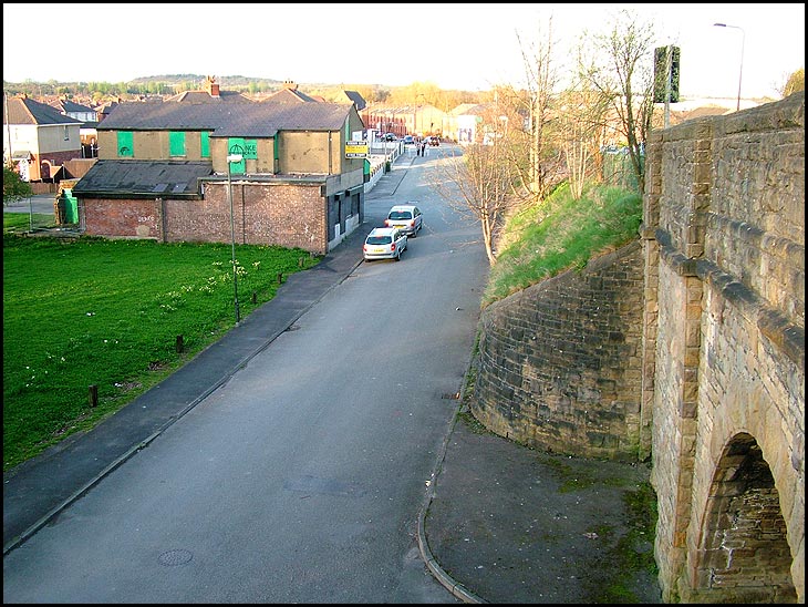
Photo: Brian (Fuji Finepix S7000)
Played round here many times as a child, with my friend who lived in the viaducts, or "viredocks", as we called it,area of Ince. I lived further uptowards Ince Bar. The building with the "for sale " sign was Whittakers Shop, owned by my friend's auntie.
When Im in this area I always wonder why Ince railway station is so long, must have had a lot of passengers at one time.
canal st was to the left of the photo the road you are seeing is ince green lane i was born at 188 bottom left of the photo at one time the canal used to go along side where canal st once was
Tony, surely Ince Green Lane goes over the church bridge top right of the photo? You can see the traffic-light there, and a street-lamp.
irene have a look at the ince directory and look for 188 ince green lane you will find the quinn family lived there and my mam was born there and later got married and had me and my two sister.canal st was just around the corner.
Tony, I was born in Ince Green Lane too, at 85, behind the wall of St. Williams Presbytery, and as you walked down towards the "viredocks", which was then Raven Street and Farmer Street, and is now Pinewood Crescent,opposite the "half-moon", Ince Green Lane then proceeded over the church bridge, at the summit of which stood Ince Station, and walking over that bridge, you could look down over the railings just before you got to the station to the road shown on the photo.A set of steps led down to Whittakers shop, (shown), and are still there today.
Tony, just doing my hubby's butties for work tomorrow in the kitchen, and it dawned on me what you mean.....Ince Green Lane BELOW the embakment was also Ince Green Lane, as was the road over the church bridge.....apologies! Our row stood back behind the wall of St. Williams Presbytery, back from the main road, opposite the Long-Neck Pub, as if it were a separate street, but it was STILL Ince Green Lane. Got there in the end,Tony, and hope your memories of your Ince childhood are as precious as mine! Irene.
i used to walk pass your house nearly every day to serve morning mass at st bills.
The houses on the other side of the church bridge was also Ince Green Lane with Raven Street and Farmer Street off it
Was the shop once the Conquering hero pub ?
irene if you look at the tarmac nr the bridge you can see where the canal ran under the arch my dad said he used to swimon the other side of the arch i used to fish for tadpoies down the docks loved it jim