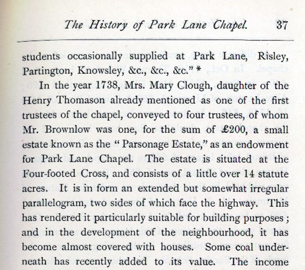
The Four-footed Cross
Gaffer suggested some possible new info on this subject and I am intrigued to see what he finds.
Started: 15th Apr 2011 at 00:30
Do you mean a Swastika/the Jaina cross, "four-footed" cross?
Replied: 15th Apr 2011 at 14:26
Sorry folks, just read the other thread in which Gaffer mentions the "Four footed Cross".
Nowt to do with Swastika's at all. ![]()
Replied: 15th Apr 2011 at 14:41
Dear Ned
Email received earlier.
The photo in question must have been very old indeed. In the book "Ancient crosses and wells of Lancashire" on page 220 the writer Henry Taylor quotes :-"FOUR FOOTED CROSS- The site of this cross, which has long since disappeared, is three miles south of Wigan, on the Roman road between that town and Warrington, in the midst of an old hunting district. Several other Lancashire crosses are known by this appellation, which means that the cross had four footings or steps, that is, the three steps or calvary, and the pedestal."
The post at Orrell was not a cross and has been variously described as a boundary marker for 3 manors,a marker post for foot races, a post for tethering horses
of the stage coaches at the Stag Inn and even possibly a monument devoted to the victory at Waterloo donated by the Holts of Bispham Hall. No one is really sure. Various newspaper clippings show different stories. In one dating from 1951 an 80 year old says he remembers the post standing in the middle of the road and can attest to the foot races. The post was 12 feet high and had a ball on top with the initials TN. The date associated with the column is 1750. TN is possibly the initials of Tom Nixon who was licensee at The Stag for a good while. The Nixon family farmed the land also at the back. One of the most plausible explanations is from AJ Hawkes who was Wigan's Librarian for a long time and was particularly interested in local history. He believed that there was a hall called Orrell Post in the 16th century and the post could have belonged to that but possibly marked the manor boundaries.
Many records for both Ashton and Orrell are lodged with our archive at Leigh town Hall and at Lancashire Record Office at Preston. The cuttings books and books I quote are available here at the Museum and are readily available for you to see.
Replied: 15th Apr 2011 at 16:59
Omnibuses
Ashton to Wigan - Monday, 9 0 a.m., 1 0 p.m. Friday, 8 0 a.m., 1 0 p.m. Saturday, 2 30 and 7 15 p.m. Sunday (from Four-footed Cross) 5 0 p.m. - James Rimmer, proprietor
English four. Amongst the word’s perhaps more surprising relatives in English are carfax ‘crossroads’ (ultimately from a post-classical Latin compound which meant literally ‘four forks’), quarantine (denoting etymologically a ‘period of 40 days’), quire ‘set of four sheets of paper’, and trapeze (literally ‘four-footed’).Could the name derive from the offset shape of the crossroads?
Replied: 15th Apr 2011 at 19:37

No.mygriffiths because the residents of the houses situated near the cross who claimed to live `At four-footed cross` had to use a distinctive`marker` exclusive to that area as a means of identifying the approximate location of their house. offset crossroads are too common in occurence to do that job....
Replied: 15th Apr 2011 at 19:49
dear ned must be very sad to see that gaffer has supported my claim that the `four-footed cross was used by horsemen to embark and disembark from their horses...ie `the three steps of cavalry` It seems my memory is much better than my `imagination,,,,,
Replied: 15th Apr 2011 at 19:57

Ray, I'm sure the writer of Gaffers e-mail meant 'Calvary' steps, not cavalry. You daft sod! ![]()
And, I can bet he's contacted Wigan History Shop for that info., so what can you expect only rubbish.
Replied: 15th Apr 2011 at 20:07
Wow I didn`t spot that Tonker ¬THree steps to Heaven` or three steps to the back of a horse. take your pick,but am I bovvered? Do I look bovvered?
Replied: 15th Apr 2011 at 21:22
Ray " No.mygriffiths because the residents of the houses situated near the cross who claimed to live `At four-footed cross` had to use a distinctive`marker` exclusive to that area as a means of identifying the approximate location of their house."
I refer you to my post on your other daft thread. No-one "claimed" to live at four-footed cross. Census enumerators had a clear area defined by the description of enumeration districts. Do you choose to ignore this?
Replied: 16th Apr 2011 at 01:56
"The photo in question must have been very old indeed."
Indeed it MUST. Im guessing some kind of time-travel.
Lets say a photo ... earliest 1880?
Henry Taylors book published 1903. Which states that "The site of this cross, which has long since disappeared.."
This makes me happy ![]()
Replied: 16th Apr 2011 at 02:07
Henry Taylor had no evidence of crosses at Bryn or Stubshaw in the late 1800s. And there are none on any maps that I have seen.
" Stubshaw Cross is a place-name attached to the junction of Lily Lane and Edge Green Lane, but any cross has vanished."
.... ANY cross has vanished.
Replied: 16th Apr 2011 at 02:16
Dear Ned
The 'photo' may well have been an artist's painting or impression. We just don't know.
Replied: 16th Apr 2011 at 10:56


Replied: 16th Apr 2011 at 16:42
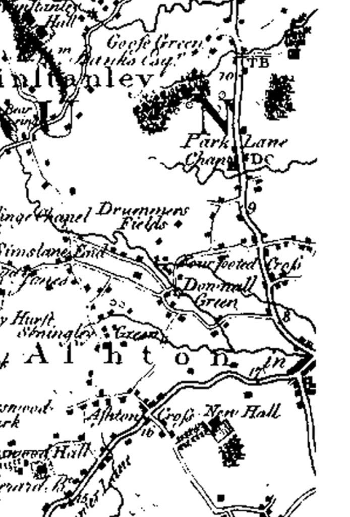
From Yates 1786 map of Lancashire.
*
Replied: 16th Apr 2011 at 19:20
David, Why are you,someone born in Stubshaw Cross, trying so hard to convince everybody that there never was a Stubshaw Cross when your own mother fought so hard to get that cross put in the garden?
And have you not yet seen the 1838 Tighe map in Ashton Library which clearly shows the cross in a position that looks to be behind and outside the wall of the garden ,As Ihave previously disclosed' And Councillor Walter Carney ,a life long historian, has agreed with me that there was a cross,and it was a signpost,and it was where I said.
And the 1847 map clearly endorses my claim that Lilly(Lily) Lane did indeed start at the garden, It must iritate you that I keep being proved right so often,,,
Replied: 16th Apr 2011 at 23:39
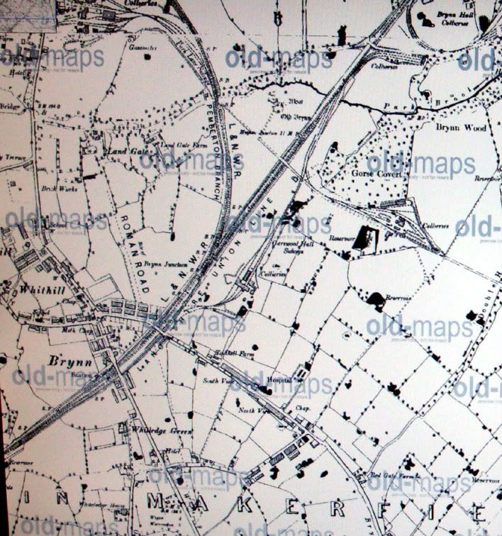
I thought the roman road that ran through to Warrington is under what is now Warrington road Abram?
Replied: 16th Apr 2011 at 23:46
It ran roughly along the route of the A49....
Replied: 16th Apr 2011 at 23:57
Shauniebabe, I believe there were two Roman roads running north from Warrington. One which the A49 roughly follows (as described by Ray) and another which ran through Lowton. That must be the Warrington Road, Abram one. ![]()
Replied: 17th Apr 2011 at 01:20
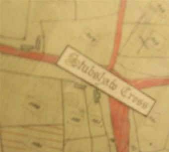
1838 Tithe Map. Is this your cross?
Replied: 18th Apr 2011 at 11:45
Last edited by dear ned: 18th Apr 2011 at 11:52:05
If so, I have to ask why is your signpost out in the middle of a field?
Replied: 18th Apr 2011 at 11:57
Ned
The Cansfield local history society published a booklet called 'A Glimpse of Ashton's Past'. It gives a different take on the topic.
I quote,
' The three crosses - Ashton, Bryn and Stubshaw were 'weeping crosses' place there as resting places for coffins on the way to a funeral.'
Replied: 18th Apr 2011 at 12:33

Gaffer, this would be the guidepost you see on the 1908 map. It's said the picture is from 1903. I doubt the post is any significant age.
Replied: 19th Apr 2011 at 01:04
Last edited by section 8: 19th Apr 2011 at 12:51:49
Section 8
Thanks. Can you see the signpost place names on the original photo? I've tried manipulating the image with Photoshop but the detail isn't clear.
Replied: 19th Apr 2011 at 09:53
Thank you gaffer that ties in with the information about Coffin Lane and wood on the funeral route from Lily Lane to Holy Trinity church.
Replied: 19th Apr 2011 at 12:29
Gaffer, I can't make out the writing, but this could be due to us viewing the back of the sign. If you notice the sign is on the far side of the post so you would think any writing would only be visible coming from Ashton. What we see could be dirt, rust or even a reversal of whats on the other side.
Replied: 19th Apr 2011 at 12:56
mygriffiths,
The mention of weeping crosses made me think also of Coffin Wood and Coffin Lane. I have heard numerous stories of why it was called Coffin lane ( some quite bizarre ) but have never found any real evidence for the name or any possible routes that could be taken. I wondered also that there may be a connection with a chapel at Brynn Hall or even the older Bryn Hall ( the one with the moat).
Im glad though that the straight path of Coffin Lane was maintained in the development of Viridor Wood.
Replied: 19th Apr 2011 at 22:19
Gaffer,
Do you think that the picture that Section 8 put on could be the picture that Mrs Derbyshire described?
Replied: 19th Apr 2011 at 22:21
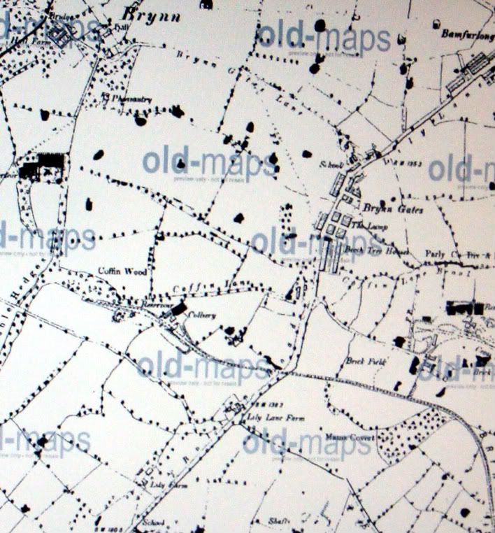
Coffin Lane was a path (still is actually) that led from Bryn Gates Lane to a mass smallpox burial ground.
Replied: 19th Apr 2011 at 22:43
Where and... where to? Maps dont show Coffin Lane coming off Bryn Gates Lane??
Replied: 19th Apr 2011 at 22:53
Dear Ned Google old maps ashton in makerfield on the genuki website and find Stubshaw cross ,you will find Coffin lane on at least two.
Replied: 20th Apr 2011 at 00:01
Ned
I'll be at the chapel tomorrow, i'll ask her.
Replied: 20th Apr 2011 at 10:39
My Griffiths
1893 Map
*
Replied: 20th Apr 2011 at 11:03
Thank you for the maps gaffer.
Replied: 20th Apr 2011 at 14:57
Yes , I had looked at some old maps a while ago... thats why I questioned Tonker saying that Coffin Lane was a path leading off Bryn Gates Lane. It doesnt. If anything it runs parallel with Bryn Gates Lane.
Replied: 20th Apr 2011 at 22:11
For gaffer - did you go to Park Lane coffee morning today?
I go every week, and I didn't see any unfamiliar faces?
Replied: 21st Apr 2011 at 17:06
Freda
No. I spoke to you last week along with Marian.I've been a regular, apart from holidays and grandchildren duties, for many years.You'll see my name on the board in the corner.
Replied: 21st Apr 2011 at 17:58
Gaffer,
Are you the person who I emailed this thread to earlier in the week?
I've only been going to Park Lane on a regular basis since I traced my Brindle ancestors to there. I have never known a group of people so friendly and helpful, and not just with History.
Replied: 21st Apr 2011 at 19:34
Freda
Yes.
Replied: 21st Apr 2011 at 20:31
Are you related to Graham, Paul and Gary then, Freda?
Replied: 21st Apr 2011 at 20:40
Tonker,
I haven't come across those names in my research,but I'd say that there is a good chance that we are connected.. My earliest Brindle was Nathaniel born about 1755. I can't find a baptism for him, but have his marriage, At that time he was the only Brindle in Ashton, I have not found any siblings or parents etc.
Every Brindle I have found so far, goes back to this
Nathaniel.
I have tried to connect him to earlier Brindles in Wigan, but no success as yet.
Replied: 22nd Apr 2011 at 11:22
Freda, Graham lives in Wigan Road, only 200 yards from Park Lane Chapel. Paul and Gary are his sons.
The older folk call the area 'Perry Brook'.
Replied: 22nd Apr 2011 at 13:21
Freda
You probably remember Graham's older sister Barbara. She lived in Canada for many years but is now back in the UK.
Replied: 22nd Apr 2011 at 13:53
thanks tonker and gaffer.
I don't know the Brindle family you mention, as I lived as a child at Kitt Green, and then Orrell. So the only people I know in the Ashton area are the ones who go to Chapel.
When I went to Ashton Grammar School,(from Kitt Green) the headmistress was Miss Annie Brindle but I don't know who her parents were, so cannot include her in my family Tree as yet.
Replied: 22nd Apr 2011 at 15:06
"... I lived as a child at Kitt Green, and then Orrell"
Kitt Green IS Orrell, Freda! ![]()
Replied: 22nd Apr 2011 at 17:36

Wrong. Technically, Kitt Green actually borders both Pemberton and Orrell...It overlaps into both...
The St Francis of Assisi Church is in Kitt Green, Pemberton; further down, H.J.Heinz is actually Kitt Green, Wigan...
A bit land locked...if you know what I mean...![]()
![]()
Replied: 22nd Apr 2011 at 17:51
This subject has been debated before. And I was proved right then too, when Gaffer posted the decider! ![]()
Replied: 22nd Apr 2011 at 18:00
just to add a bit more confusion to the issue.
I'm talking about Kitt Green before St. Francis of Assisi, before Heinz factory and definitely before Marsh Green and Norley Hall Estate were anywhere near Kitt Green. which consisted of:
City Rd. Bell Lane, Prescott Lane, Latham Lane, Springs Rd. Smith's Ave, Denton Grove, Eccles Rd. Peter St. Charles St. Hartley Grove.and Norley Rd. I don't think that I have missed anything out.
Our Postal Address was Bell Lane, Kitt Green, Nr. Wigan
Replied: 22nd Apr 2011 at 19:12
Bell Lane is, clearly, in Orrell. ![]()
Replied: 22nd Apr 2011 at 20:52
...St Francis's church is clearly in Pemberton...![]()
Replied: 22nd Apr 2011 at 20:55
Replied: 22nd Apr 2011 at 21:08
![]()
Replied: 22nd Apr 2011 at 21:15
Freda says she lived in Bell Lane, NOT in St.Francis of Assisi church (in Liverpool! ![]() ).
).
Bell Lane is in Orrell.
Kitt Green is on the opposite side of City Road to Norley Estate (that's Norley Estate, not Norley Hall 'Council' housing estate) which is in Pemberton. It doesn't cover both places, it's only Kitt Green on the Orrell side of City Road.
St Francis of Assisi church was built on Norley Estate, in Pemberton.
Maybe Gaffer will post a picture of a map tp prove it? ![]()
Replied: 22nd Apr 2011 at 21:25
Last edited by tonker: 22nd Apr 2011 at 21:28:09
Ask the Vicar...![]()
![]()
Replied: 22nd Apr 2011 at 21:27
What vicar? And ask him what?
Replied: 22nd Apr 2011 at 21:29

said the actress to the bishop
Replied: 22nd Apr 2011 at 21:31
![]()
Replied: 22nd Apr 2011 at 21:32