Wigan Album
Scholes
9 Comments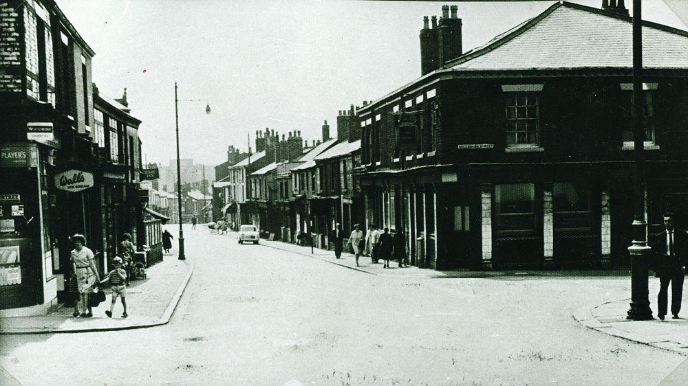
Photo: Darren Bishop
Item #: 7741
Great memories of old.
can anyone tell me if boyswell lane is on this photo or if not whereabouts it was- trying to find a photo of it thanks
I can't beleive how much Scholes has changed. Am I right in thinking this is looking down towards Wigan? Were the pub is now are the block of flats, stepped back a little?
Where the Windmill (top longpull)Pub is, the high rise flats built behind, is Boyswell House. My in-laws lived there, moved from the demolished Oxford St..
Hi Vic
Boyswell Lane is given as 120 Scholes - but can't find it on the 1907 map... trying to dredge up the address for the Windmill...
Re: Boyswell Lane. The first building after Vauxhall Rd was # 130 ( see pic by Ron Dawber "Looking up Scholes from corner of Vauxhall Rd., 1960s." which is on page 1 of the Scholes section.) By counting on the 1907 map Boyswell Lane appears to be directly opposite the Scholes / Windmill St junction - but I could be wrong !
Used to work in a TV rental shop/repairs just past the pub on the right. There was a pie shop facing with the best pies I have ever tasted. Then you had a tripe shop on the same block. Used to get the tripe & cowheels for my Mum. Could stand it myself. Give me the pies anyday. The sweet shop on the corner was another haunt for a sweet tooth.
Sheeringtons on Scolfield lane. next block up was Mrs Davies groecery shop. Out door next block where I used to call for pop. Up from there was another sweet& grocery. Then turn left into the street I cant recall to De-romas just past them was the coal mercahnsts into Linney St. What a walk I have just had LovelyEh!
I lived next door but one to Mrs Davies' shop in Scholefield Lane and next to George Conroys greengrocers on the corner of Neville St. On the other corner was Hollands off licence. Further up was the sweet shop you refer to called Monicas I think. There were a few terraced houses around there with steps up to them I think. The next street was Florrie St, where the coal merchants was located, leading into Linney St. In the next row was the Mount Pleasant pub where my Gt uncle John Molyneux and family who lived at 37 Linney St used to frequent. My Granddad Jack Critchley (Golborne St) used to play the piano in The Mount for many years. He couldn't read a note of music but boy could he play the piano! He could change key whenever a singer asked too. Wish I had his talent. There was a sweet shop (I think) on the corner of Catherine St and Scholefield Lane the name of which escapes me. Then St Catharine's infants and junior school on the other side of Catherine St and which I attended. With the next row of terraced houses was then The Spotted Cow pub on the way down to Birkett Bank. Don't remember any shops on the other side of Scholefield Lane though. There was a hotel facing Scholeield Lane in Birkett Bank that was demolished when I was a nipper but used to walk past with St Catharine's walking day.
Can anyone shed light on 255 Scholes. My great grandad William Bennett moved back to Wigan from mining work in County Durham to become a greengrocer/fruiterer at this address, possibly though until the 50’s.