Wigan Album
Newtown
2 Comments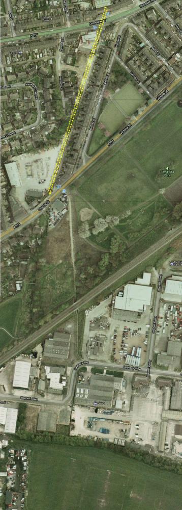
Photo: Banksy
Item #: 17630
I've just done a rough aerial view of the train line at the back of Mitchell Street but not sure the route from crossing Victoria Street, possible it went at the side of the delph through to Little Lane or maybe down the Pad at the top of the park and under the bridge on the photo? also was always told that Pemberton started and Newtown stopped at Union Bridge?
(Fred's Comment in 2008)
Re: Union Bridge Comments by fred foster, 1st May 2008
The bridge carried coal from Norley Collieries to the marshalling yards at Blundells. The line ran behind Mitchell St. and crossed the road near Jewsons. The two houses by Jewsons were the crossing keepers cottages. We had an allotment bordering the track and my mother would hold me up to watch the loco as it pushed the loaded wagons.The line passed under 2 bridges and then came out in Little Lane, under another bridge.The line was closed down and the bridges filled in in the 1930s.
Go to "oldmaps.co.uk", enter Wigan and search through the available maps for the Newton area. The Mineral Line is clearly shown, coming from the Pemberton Collieries, passing under Little Lane heading north across the main road at Jewsons, behinf Mitchell Street and then over Ormskirk Road at "Union Bridge". It then heads in a curve out towards Martland Mill picking up various recognisable land marks across Worsley Hall out towards the Orrell Brickworks and Colliery. It then heads off the available map towards Standish lower Ground. It isn;t shown on the earlir maps in the 1890's but there is a tramway on a similar route from Pemberton Collieries which heads towards the Bridge which crosses Wallgate near Asda and is linked into the main line system by what is refered to as an "Inclined Plane"> These old OS maps of the Wigan area (and others) ae very useful.
hi, dave the bridge in question i am sure its not union bridge its the one on warrington road towards goose green. i am 70 yrs old and lived in heather grove the embankement for the rail lines were at the bottom of our garden and came from a very large tip near plane avenue i did pick coal from the slag heap. hope that helps a bit.also john plumpton made furniture, and had a building firm.