Wigan Album
pemberton centre
11 Comments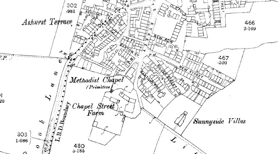
Photo: Mick
Item #: 21460
Mick
Many thanks for posting this. I have been looking for information on some of these places on the map for years.
It is really appreciated.
What date is the map? Where did you get it from. The only Pemberton one I have is possibly newer and doesn't cover the centre of Pem.
Mick
Can you please show the 2 sections, one that shows York St and the other the Fleet St bit? My 2 Gt Grandpa was a hairdresser in York St. His name wa Ashurst so the Ashurst Terrace and Ashurst fold made me curious as well.Thanks again.
Tricia - I'll see what I can sort out for you.
Carol - as stated in the photo caption, the map dates to circa 1890.
Thanks, Mick. Coincidence is strange , as well! On the cricket playing thread, my Grandpa was a Master Baker and was approached by the Jacksons to go into business with them . He declined as he did not want to risk his money with a wife and child to think about. Big mistake! one by one the Jacksons all died off and my Dad was an only child!
Strange that both those photos should crop up together. Also my Gran had Dad lined up to marry someone whose father made linings for coffins... wonder if that is the same family that was mentioned re making coffins? Grandpa died before I was born but my brother remembers him well.
tricia, the person who made coffins there is name was John.C.Gore the brother of William.C.Gore. Alexandra Court nursing home is now where is works used to be,in Howard St.
Thank you for sharing the map. My mother was born at Smethurst Farm, Pemberton. Her father, John Green, grew up there in the early 1900s. I believe they have turned the farm into flats.
Tricia - I've unloaded the area of map covering Fleet St as you requested.
Can you refresh my memory for me and tell me whereabouts York St was, and I'll see if I can find it for you.
Thanks for that, Mick. York St, I think, ran parallel to Orrell Road somewhere down from near Bradshaw St to Loch Street area. Really grateful for your help.
Thanks for that, wigie Its a different family though. The one I mentioned was a family called Fishwick. My maternal Grandma's mother was a Fishwick and it is such a common name in that area that I came to a halt at a wedding in 1830.
Senior moment there! I should have said Paternal Grandmother!